You are here: Home > Network List > TA - USArray Transportable Network (new EarthScope stations) Stations List
> Station H62A Milan, NH, USA > Earthquake Result Viewer
H62A Milan, NH, USA - Earthquake Result Viewer
| Earthquake location: |
Sea Of Okhotsk |
| Earthquake latitude/longitude: |
53.2/152.8 |
| Earthquake time(UTC): |
2013/10/01 (274) 03:38:21 GMT |
| Earthquake Depth: |
573 km |
| Earthquake Magnitude: |
6.7 MWW, 6.7 MWC, 6.8 MWC, 6.8 MWB |
| Earthquake Catalog/Contributor: |
NEIC PDE/NEIC COMCAT |
|
| Network: |
TA USArray Transportable Network (new EarthScope stations) |
| Station: |
H62A Milan, NH, USA |
| Lat/Lon: |
44.57 N/71.16 W |
| Elevation: |
381 m |
|
| Distance: |
75.6 deg |
| Az: |
30.803 deg |
| Baz: |
334.465 deg |
| Ray Param: |
0.04973452 |
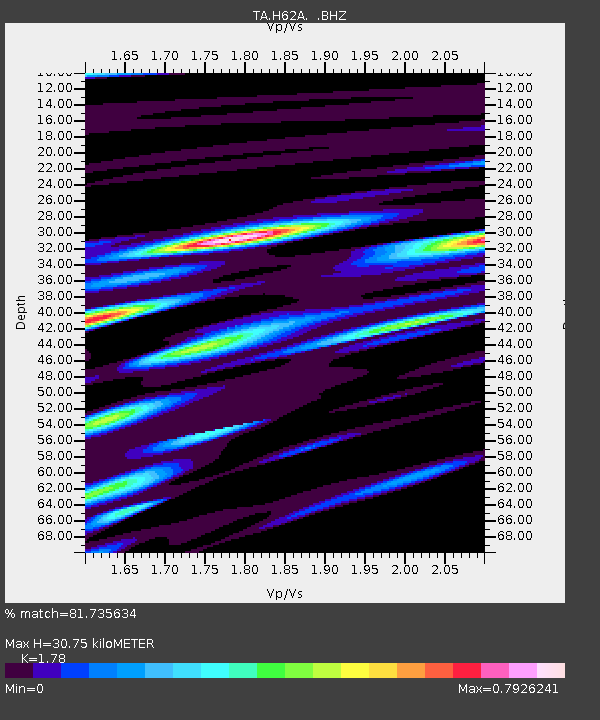
| Estimated Moho Depth: |
30.75 km |
| Estimated Crust Vp/Vs: |
1.78 |
| Assumed Crust Vp: |
6.419 km/s |
| Estimated Crust Vs: |
3.606 km/s |
| Estimated Crust Poisson's Ratio: |
0.27 |
|
| Radial Match: |
81.735634 % |
| Radial Bump: |
400 |
| Transverse Match: |
69.60401 % |
| Transverse Bump: |
400 |
| SOD ConfigId: |
626651 |
| Insert Time: |
2014-04-18 23:19:29.063 +0000 |
| GWidth: |
2.5 |
| Max Bumps: |
400 |
| Tol: |
0.001 |
|
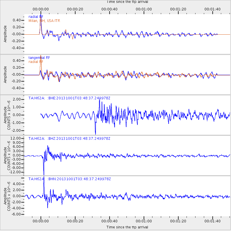
Signal To Noise
| Channel | StoN | STA | LTA |
| TA:H62A: :BHZ:20131001T03:48:37.249978Z | 14.056905 | 4.035036E-6 | 2.870501E-7 |
| TA:H62A: :BHN:20131001T03:48:37.249978Z | 6.486125 | 1.7081269E-6 | 2.633509E-7 |
| TA:H62A: :BHE:20131001T03:48:37.249978Z | 3.0242085 | 8.029505E-7 | 2.6550765E-7 |
| Arrivals |
| Ps | 3.8 SECOND |
| PpPs | 13 SECOND |
| PsPs/PpSs | 17 SECOND |


