You are here: Home > Network List > TA - USArray Transportable Network (new EarthScope stations) Stations List
> Station I42A Draeger Farm, Ripon, WI, USA > Earthquake Result Viewer
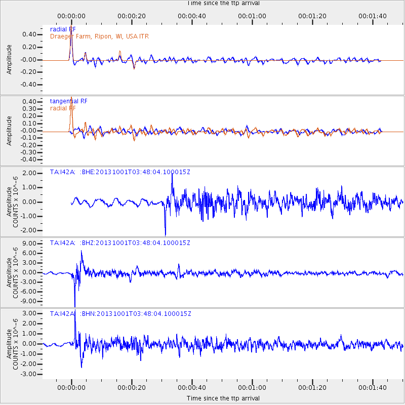
I42A Draeger Farm, Ripon, WI, USA - Earthquake Result Viewer
*The percent match for this event was below the threshold and hence no stack was calculated.
| Earthquake location: |
Sea Of Okhotsk |
| Earthquake latitude/longitude: |
53.2/152.8 |
| Earthquake time(UTC): |
2013/10/01 (274) 03:38:21 GMT |
| Earthquake Depth: |
573 km |
| Earthquake Magnitude: |
6.7 MWW, 6.7 MWC, 6.8 MWC, 6.8 MWB |
| Earthquake Catalog/Contributor: |
NEIC PDE/NEIC COMCAT |
|
| Network: |
TA USArray Transportable Network (new EarthScope stations) |
| Station: |
I42A Draeger Farm, Ripon, WI, USA |
| Lat/Lon: |
43.89 N/88.91 W |
| Elevation: |
298 m |
|
| Distance: |
69.8 deg |
| Az: |
42.717 deg |
| Baz: |
325.633 deg |
| Ray Param: |
$rayparam |
*The percent match for this event was below the threshold and hence was not used in the summary stack. |
|
| Radial Match: |
77.38226 % |
| Radial Bump: |
379 |
| Transverse Match: |
63.16295 % |
| Transverse Bump: |
400 |
| SOD ConfigId: |
626651 |
| Insert Time: |
2014-04-18 23:19:57.400 +0000 |
| GWidth: |
2.5 |
| Max Bumps: |
400 |
| Tol: |
0.001 |
|
Signal To Noise
| Channel | StoN | STA | LTA |
| TA:I42A: :BHZ:20131001T03:48:04.100015Z | 13.101542 | 3.0534984E-6 | 2.3306403E-7 |
| TA:I42A: :BHN:20131001T03:48:04.100015Z | 5.918812 | 9.939298E-7 | 1.6792725E-7 |
| TA:I42A: :BHE:20131001T03:48:04.100015Z | 4.133585 | 7.097997E-7 | 1.7171527E-7 |
| Arrivals |
| Ps | |
| PpPs | |
| PsPs/PpSs | |


