You are here: Home > Network List > TA - USArray Transportable Network (new EarthScope stations) Stations List
> Station I59A Olmsteadville, NY, USA > Earthquake Result Viewer
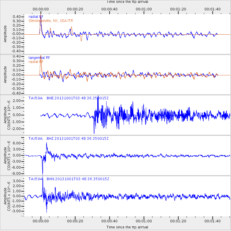
I59A Olmsteadville, NY, USA - Earthquake Result Viewer
*The percent match for this event was below the threshold and hence no stack was calculated.
| Earthquake location: |
Sea Of Okhotsk |
| Earthquake latitude/longitude: |
53.2/152.8 |
| Earthquake time(UTC): |
2013/10/01 (274) 03:38:21 GMT |
| Earthquake Depth: |
573 km |
| Earthquake Magnitude: |
6.7 MWW, 6.7 MWC, 6.8 MWC, 6.8 MWB |
| Earthquake Catalog/Contributor: |
NEIC PDE/NEIC COMCAT |
|
| Network: |
TA USArray Transportable Network (new EarthScope stations) |
| Station: |
I59A Olmsteadville, NY, USA |
| Lat/Lon: |
43.80 N/73.87 W |
| Elevation: |
390 m |
|
| Distance: |
75.4 deg |
| Az: |
32.971 deg |
| Baz: |
333.119 deg |
| Ray Param: |
$rayparam |
*The percent match for this event was below the threshold and hence was not used in the summary stack. |
|
| Radial Match: |
78.52604 % |
| Radial Bump: |
400 |
| Transverse Match: |
69.479774 % |
| Transverse Bump: |
400 |
| SOD ConfigId: |
626651 |
| Insert Time: |
2014-04-18 23:20:31.156 +0000 |
| GWidth: |
2.5 |
| Max Bumps: |
400 |
| Tol: |
0.001 |
|
Signal To Noise
| Channel | StoN | STA | LTA |
| TA:I59A: :BHZ:20131001T03:48:36.350015Z | 10.757182 | 2.8506763E-6 | 2.6500214E-7 |
| TA:I59A: :BHN:20131001T03:48:36.350015Z | 5.339861 | 1.0899741E-6 | 2.0412034E-7 |
| TA:I59A: :BHE:20131001T03:48:36.350015Z | 5.714951 | 8.422169E-7 | 1.4737078E-7 |
| Arrivals |
| Ps | |
| PpPs | |
| PsPs/PpSs | |


