You are here: Home > Network List > TA - USArray Transportable Network (new EarthScope stations) Stations List
> Station K58A Earlville, NY, USA > Earthquake Result Viewer
K58A Earlville, NY, USA - Earthquake Result Viewer
| Earthquake location: |
Sea Of Okhotsk |
| Earthquake latitude/longitude: |
53.2/152.8 |
| Earthquake time(UTC): |
2013/10/01 (274) 03:38:21 GMT |
| Earthquake Depth: |
573 km |
| Earthquake Magnitude: |
6.7 MWW, 6.7 MWC, 6.8 MWC, 6.8 MWB |
| Earthquake Catalog/Contributor: |
NEIC PDE/NEIC COMCAT |
|
| Network: |
TA USArray Transportable Network (new EarthScope stations) |
| Station: |
K58A Earlville, NY, USA |
| Lat/Lon: |
42.76 N/75.65 W |
| Elevation: |
509 m |
|
| Distance: |
75.7 deg |
| Az: |
34.647 deg |
| Baz: |
332.326 deg |
| Ray Param: |
0.049631644 |
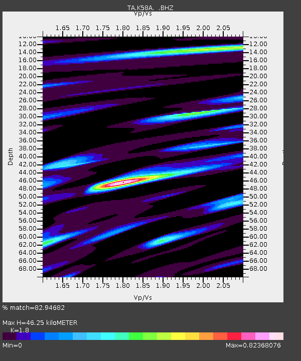
| Estimated Moho Depth: |
46.25 km |
| Estimated Crust Vp/Vs: |
1.80 |
| Assumed Crust Vp: |
6.419 km/s |
| Estimated Crust Vs: |
3.566 km/s |
| Estimated Crust Poisson's Ratio: |
0.28 |
|
| Radial Match: |
82.94682 % |
| Radial Bump: |
400 |
| Transverse Match: |
61.611954 % |
| Transverse Bump: |
400 |
| SOD ConfigId: |
626651 |
| Insert Time: |
2014-04-18 23:22:18.345 +0000 |
| GWidth: |
2.5 |
| Max Bumps: |
400 |
| Tol: |
0.001 |
|
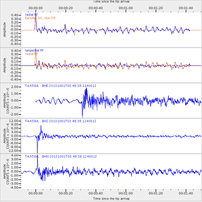
Signal To Noise
| Channel | StoN | STA | LTA |
| TA:K58A: :BHZ:20131001T03:48:38.124001Z | 13.640181 | 3.683808E-6 | 2.7007033E-7 |
| TA:K58A: :BHN:20131001T03:48:38.124001Z | 4.4572973 | 1.1892838E-6 | 2.6681727E-7 |
| TA:K58A: :BHE:20131001T03:48:38.124001Z | 3.8687768 | 8.832063E-7 | 2.2829084E-7 |
| Arrivals |
| Ps | 5.9 SECOND |
| PpPs | 20 SECOND |
| PsPs/PpSs | 26 SECOND |


