You are here: Home > Network List > TA - USArray Transportable Network (new EarthScope stations) Stations List
> Station L04D Klamath Falls, OR, USA > Earthquake Result Viewer
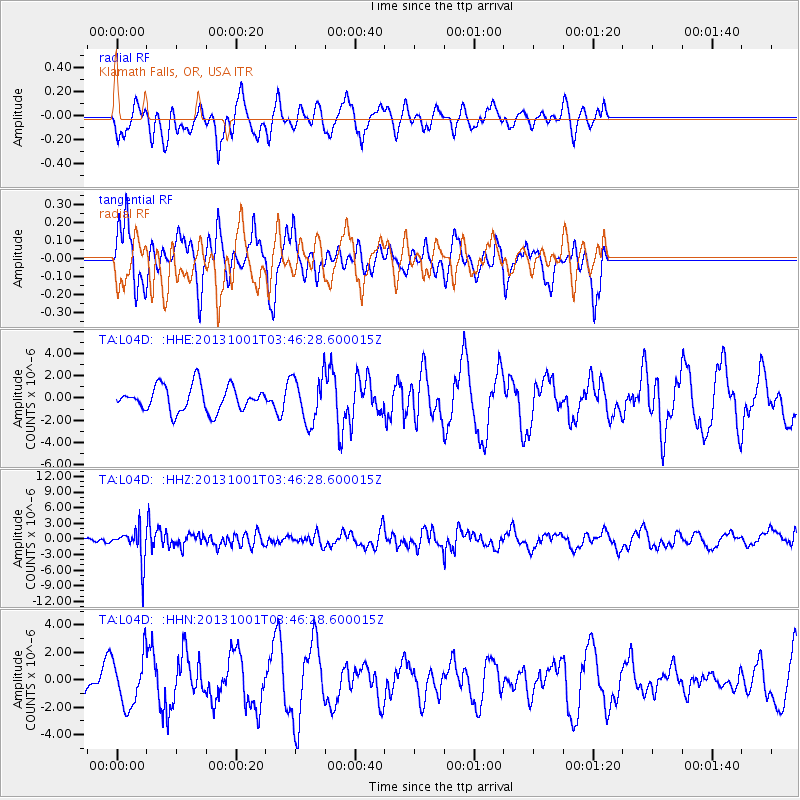
L04D Klamath Falls, OR, USA - Earthquake Result Viewer
*The percent match for this event was below the threshold and hence no stack was calculated.
| Earthquake location: |
Sea Of Okhotsk |
| Earthquake latitude/longitude: |
53.2/152.8 |
| Earthquake time(UTC): |
2013/10/01 (274) 03:38:21 GMT |
| Earthquake Depth: |
573 km |
| Earthquake Magnitude: |
6.7 MWW, 6.7 MWC, 6.8 MWC, 6.8 MWB |
| Earthquake Catalog/Contributor: |
NEIC PDE/NEIC COMCAT |
|
| Network: |
TA USArray Transportable Network (new EarthScope stations) |
| Station: |
L04D Klamath Falls, OR, USA |
| Lat/Lon: |
42.22 N/122.30 W |
| Elevation: |
1437 m |
|
| Distance: |
54.9 deg |
| Az: |
64.677 deg |
| Baz: |
312.94 deg |
| Ray Param: |
$rayparam |
*The percent match for this event was below the threshold and hence was not used in the summary stack. |
|
| Radial Match: |
45.722977 % |
| Radial Bump: |
372 |
| Transverse Match: |
76.18887 % |
| Transverse Bump: |
276 |
| SOD ConfigId: |
626651 |
| Insert Time: |
2014-04-18 23:22:42.634 +0000 |
| GWidth: |
2.5 |
| Max Bumps: |
400 |
| Tol: |
0.001 |
|
Signal To Noise
| Channel | StoN | STA | LTA |
| TA:L04D: :HHZ:20131001T03:46:28.600015Z | 5.187534 | 3.2760888E-6 | 6.3153107E-7 |
| TA:L04D: :HHN:20131001T03:46:28.600015Z | 1.893109 | 1.8017475E-6 | 9.5174E-7 |
| TA:L04D: :HHE:20131001T03:46:28.600015Z | 1.8019891 | 2.0323143E-6 | 1.1278172E-6 |
| Arrivals |
| Ps | |
| PpPs | |
| PsPs/PpSs | |


