You are here: Home > Network List > TA - USArray Transportable Network (new EarthScope stations) Stations List
> Station L49A Milan, MI, USA > Earthquake Result Viewer
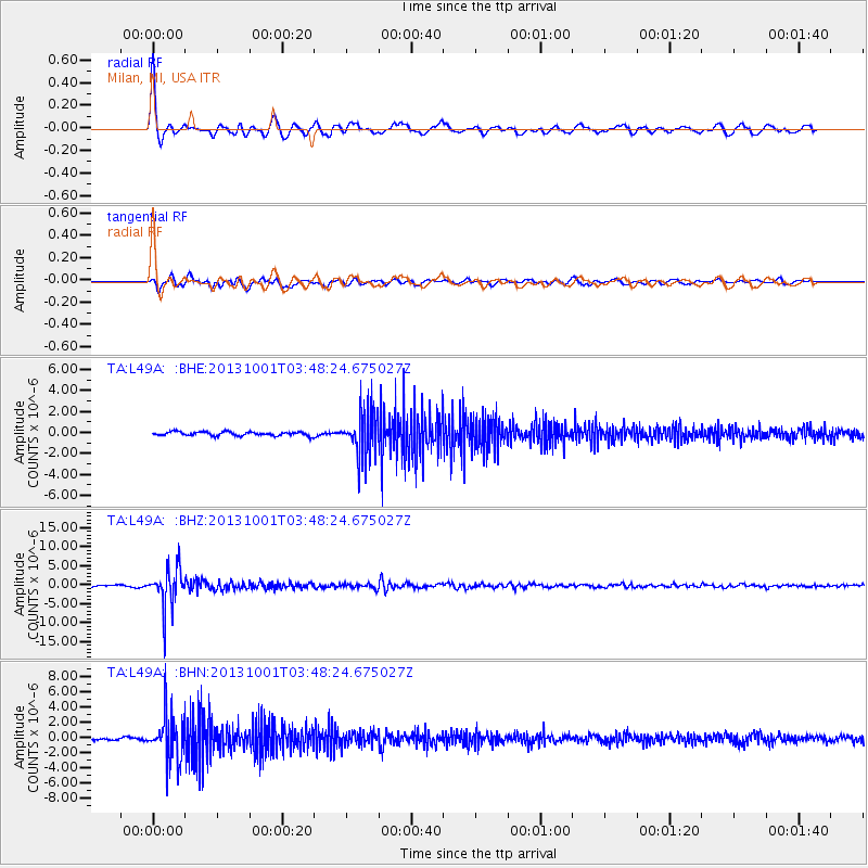
L49A Milan, MI, USA - Earthquake Result Viewer

| Earthquake location: |
Sea Of Okhotsk |
| Earthquake latitude/longitude: |
53.2/152.8 |
| Earthquake time(UTC): |
2013/10/01 (274) 03:38:21 GMT |
| Earthquake Depth: |
573 km |
| Earthquake Magnitude: |
6.7 MWW, 6.7 MWC, 6.8 MWC, 6.8 MWB |
| Earthquake Catalog/Contributor: |
NEIC PDE/NEIC COMCAT |
|
| Network: |
TA USArray Transportable Network (new EarthScope stations) |
| Station: |
L49A Milan, MI, USA |
| Lat/Lon: |
42.11 N/83.77 W |
| Elevation: |
230 m |
|
| Distance: |
73.3 deg |
| Az: |
40.401 deg |
| Baz: |
328.398 deg |
| Ray Param: |
0.05118351 |
| Estimated Moho Depth: |
47.75 km |
| Estimated Crust Vp/Vs: |
1.64 |
| Assumed Crust Vp: |
6.483 km/s |
| Estimated Crust Vs: |
3.941 km/s |
| Estimated Crust Poisson's Ratio: |
0.21 |
|
| Radial Match: |
84.73637 % |
| Radial Bump: |
400 |
| Transverse Match: |
76.06091 % |
| Transverse Bump: |
400 |
| SOD ConfigId: |
626651 |
| Insert Time: |
2014-04-18 23:22:54.695 +0000 |
| GWidth: |
2.5 |
| Max Bumps: |
400 |
| Tol: |
0.001 |
|
Signal To Noise
| Channel | StoN | STA | LTA |
| TA:L49A: :BHZ:20131001T03:48:24.675027Z | 32.995586 | 5.2355676E-6 | 1.5867478E-7 |
| TA:L49A: :BHN:20131001T03:48:24.675027Z | 16.341278 | 2.94431E-6 | 1.8017623E-7 |
| TA:L49A: :BHE:20131001T03:48:24.675027Z | 11.574872 | 2.1894034E-6 | 1.8915141E-7 |
| Arrivals |
| Ps | 4.9 SECOND |
| PpPs | 19 SECOND |
| PsPs/PpSs | 24 SECOND |


