You are here: Home > Network List > TA - USArray Transportable Network (new EarthScope stations) Stations List
> Station P51A Williamsport, OH, USA > Earthquake Result Viewer
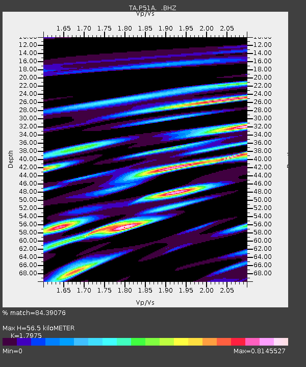
P51A Williamsport, OH, USA - Earthquake Result Viewer
| Earthquake location: |
Sea Of Okhotsk |
| Earthquake latitude/longitude: |
53.2/152.8 |
| Earthquake time(UTC): |
2013/10/01 (274) 03:38:21 GMT |
| Earthquake Depth: |
573 km |
| Earthquake Magnitude: |
6.7 MWW, 6.7 MWC, 6.8 MWC, 6.8 MWB |
| Earthquake Catalog/Contributor: |
NEIC PDE/NEIC COMCAT |
|
| Network: |
TA USArray Transportable Network (new EarthScope stations) |
| Station: |
P51A Williamsport, OH, USA |
| Lat/Lon: |
39.48 N/83.06 W |
| Elevation: |
211 m |
|
| Distance: |
75.8 deg |
| Az: |
41.337 deg |
| Baz: |
329.107 deg |
| Ray Param: |
0.04955625 |
| Estimated Moho Depth: |
56.5 km |
| Estimated Crust Vp/Vs: |
1.80 |
| Assumed Crust Vp: |
6.232 km/s |
| Estimated Crust Vs: |
3.467 km/s |
| Estimated Crust Poisson's Ratio: |
0.28 |
|
| Radial Match: |
84.39076 % |
| Radial Bump: |
400 |
| Transverse Match: |
62.522205 % |
| Transverse Bump: |
400 |
| SOD ConfigId: |
626651 |
| Insert Time: |
2014-04-18 23:26:24.395 +0000 |
| GWidth: |
2.5 |
| Max Bumps: |
400 |
| Tol: |
0.001 |
|

Signal To Noise
| Channel | StoN | STA | LTA |
| TA:P51A: :BHZ:20131001T03:48:38.749978Z | 12.420034 | 2.5410714E-6 | 2.0459454E-7 |
| TA:P51A: :BHN:20131001T03:48:38.749978Z | 7.89113 | 1.2350861E-6 | 1.5651575E-7 |
| TA:P51A: :BHE:20131001T03:48:38.749978Z | 3.331371 | 5.8633304E-7 | 1.7600354E-7 |
| Arrivals |
| Ps | 7.4 SECOND |
| PpPs | 25 SECOND |
| PsPs/PpSs | 32 SECOND |


