You are here: Home > Network List > TA - USArray Transportable Network (new EarthScope stations) Stations List
> Station Q50A Georgetown, OH, USA > Earthquake Result Viewer
Q50A Georgetown, OH, USA - Earthquake Result Viewer
| Earthquake location: |
Sea Of Okhotsk |
| Earthquake latitude/longitude: |
53.2/152.8 |
| Earthquake time(UTC): |
2013/10/01 (274) 03:38:21 GMT |
| Earthquake Depth: |
573 km |
| Earthquake Magnitude: |
6.7 MWW, 6.7 MWC, 6.8 MWC, 6.8 MWB |
| Earthquake Catalog/Contributor: |
NEIC PDE/NEIC COMCAT |
|
| Network: |
TA USArray Transportable Network (new EarthScope stations) |
| Station: |
Q50A Georgetown, OH, USA |
| Lat/Lon: |
38.84 N/83.98 W |
| Elevation: |
262 m |
|
| Distance: |
76.0 deg |
| Az: |
42.307 deg |
| Baz: |
328.765 deg |
| Ray Param: |
0.04944163 |
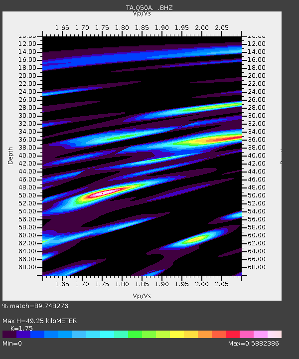
| Estimated Moho Depth: |
49.25 km |
| Estimated Crust Vp/Vs: |
1.75 |
| Assumed Crust Vp: |
6.232 km/s |
| Estimated Crust Vs: |
3.561 km/s |
| Estimated Crust Poisson's Ratio: |
0.26 |
|
| Radial Match: |
89.748276 % |
| Radial Bump: |
400 |
| Transverse Match: |
72.60167 % |
| Transverse Bump: |
400 |
| SOD ConfigId: |
626651 |
| Insert Time: |
2014-04-18 23:27:05.618 +0000 |
| GWidth: |
2.5 |
| Max Bumps: |
400 |
| Tol: |
0.001 |
|
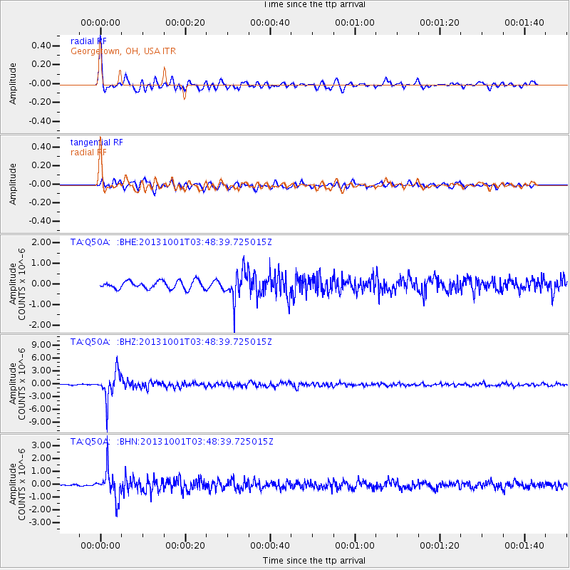
Signal To Noise
| Channel | StoN | STA | LTA |
| TA:Q50A: :BHZ:20131001T03:48:39.725015Z | 22.74278 | 3.249312E-6 | 1.4287224E-7 |
| TA:Q50A: :BHN:20131001T03:48:39.725015Z | 11.652188 | 1.1297626E-6 | 9.695712E-8 |
| TA:Q50A: :BHE:20131001T03:48:39.725015Z | 3.6336558 | 6.952301E-7 | 1.9133076E-7 |
| Arrivals |
| Ps | 6.1 SECOND |
| PpPs | 21 SECOND |
| PsPs/PpSs | 27 SECOND |


