You are here: Home > Network List > TA - USArray Transportable Network (new EarthScope stations) Stations List
> Station Q54A Coxs Mills, WV, USA > Earthquake Result Viewer
Q54A Coxs Mills, WV, USA - Earthquake Result Viewer
| Earthquake location: |
Sea Of Okhotsk |
| Earthquake latitude/longitude: |
53.2/152.8 |
| Earthquake time(UTC): |
2013/10/01 (274) 03:38:21 GMT |
| Earthquake Depth: |
573 km |
| Earthquake Magnitude: |
6.7 MWW, 6.7 MWC, 6.8 MWC, 6.8 MWB |
| Earthquake Catalog/Contributor: |
NEIC PDE/NEIC COMCAT |
|
| Network: |
TA USArray Transportable Network (new EarthScope stations) |
| Station: |
Q54A Coxs Mills, WV, USA |
| Lat/Lon: |
38.98 N/80.83 W |
| Elevation: |
254 m |
|
| Distance: |
77.2 deg |
| Az: |
40.061 deg |
| Baz: |
330.212 deg |
| Ray Param: |
0.048707917 |
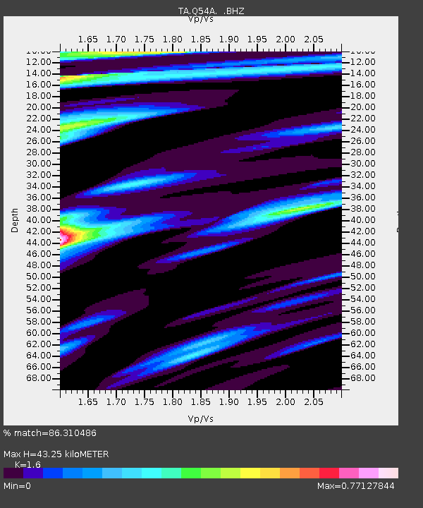
| Estimated Moho Depth: |
43.25 km |
| Estimated Crust Vp/Vs: |
1.60 |
| Assumed Crust Vp: |
6.207 km/s |
| Estimated Crust Vs: |
3.879 km/s |
| Estimated Crust Poisson's Ratio: |
0.18 |
|
| Radial Match: |
86.310486 % |
| Radial Bump: |
400 |
| Transverse Match: |
78.76833 % |
| Transverse Bump: |
400 |
| SOD ConfigId: |
626651 |
| Insert Time: |
2014-04-18 23:27:17.123 +0000 |
| GWidth: |
2.5 |
| Max Bumps: |
400 |
| Tol: |
0.001 |
|
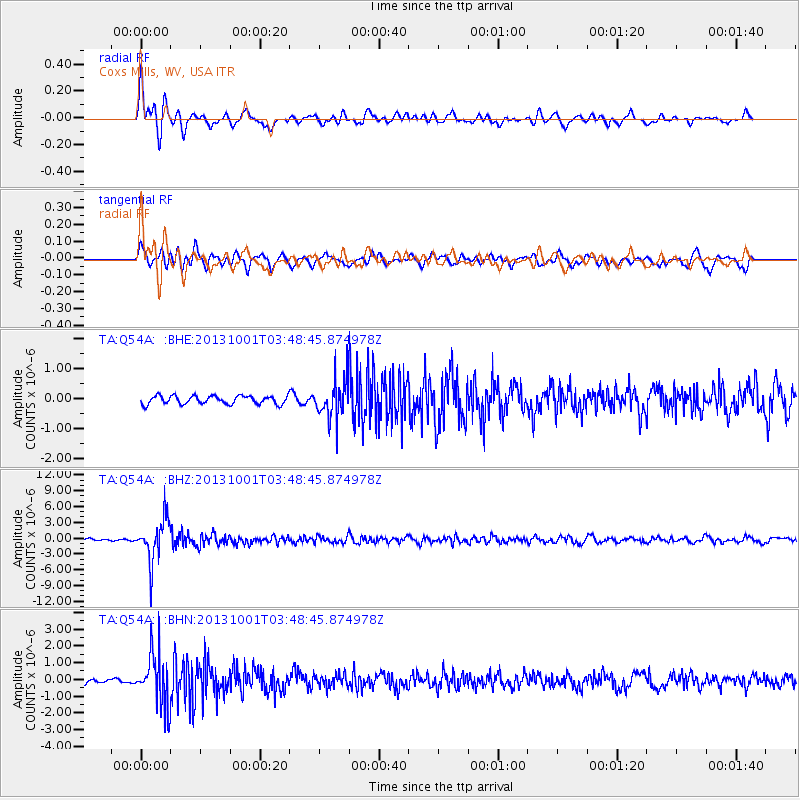
Signal To Noise
| Channel | StoN | STA | LTA |
| TA:Q54A: :BHZ:20131001T03:48:45.874978Z | 23.801338 | 4.075707E-6 | 1.7123855E-7 |
| TA:Q54A: :BHN:20131001T03:48:45.874978Z | 11.722919 | 1.5999093E-6 | 1.3647703E-7 |
| TA:Q54A: :BHE:20131001T03:48:45.874978Z | 4.546106 | 6.2468894E-7 | 1.3741189E-7 |
| Arrivals |
| Ps | 4.3 SECOND |
| PpPs | 18 SECOND |
| PsPs/PpSs | 22 SECOND |


