You are here: Home > Network List > TA - USArray Transportable Network (new EarthScope stations) Stations List
> Station R50A Paris, KY, USA > Earthquake Result Viewer
R50A Paris, KY, USA - Earthquake Result Viewer
| Earthquake location: |
Sea Of Okhotsk |
| Earthquake latitude/longitude: |
53.2/152.8 |
| Earthquake time(UTC): |
2013/10/01 (274) 03:38:21 GMT |
| Earthquake Depth: |
573 km |
| Earthquake Magnitude: |
6.7 MWW, 6.7 MWC, 6.8 MWC, 6.8 MWB |
| Earthquake Catalog/Contributor: |
NEIC PDE/NEIC COMCAT |
|
| Network: |
TA USArray Transportable Network (new EarthScope stations) |
| Station: |
R50A Paris, KY, USA |
| Lat/Lon: |
38.28 N/84.33 W |
| Elevation: |
255 m |
|
| Distance: |
76.4 deg |
| Az: |
42.847 deg |
| Baz: |
328.678 deg |
| Ray Param: |
0.049223367 |
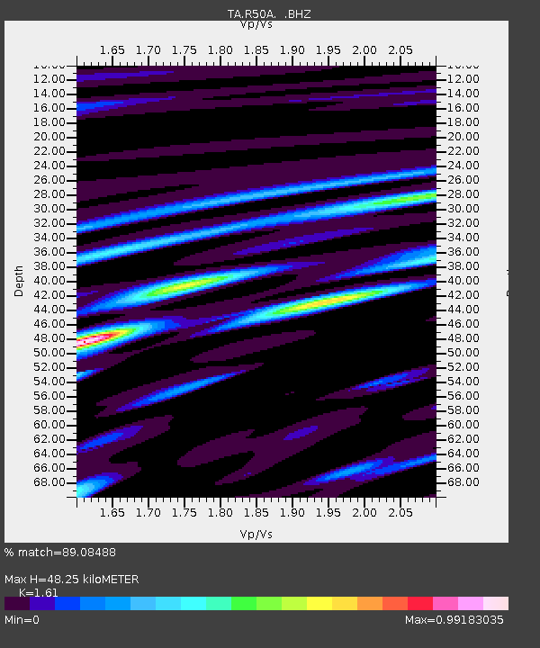
| Estimated Moho Depth: |
48.25 km |
| Estimated Crust Vp/Vs: |
1.61 |
| Assumed Crust Vp: |
6.498 km/s |
| Estimated Crust Vs: |
4.036 km/s |
| Estimated Crust Poisson's Ratio: |
0.19 |
|
| Radial Match: |
89.08488 % |
| Radial Bump: |
400 |
| Transverse Match: |
80.03835 % |
| Transverse Bump: |
400 |
| SOD ConfigId: |
626651 |
| Insert Time: |
2014-04-18 23:27:43.302 +0000 |
| GWidth: |
2.5 |
| Max Bumps: |
400 |
| Tol: |
0.001 |
|

Signal To Noise
| Channel | StoN | STA | LTA |
| TA:R50A: :BHZ:20131001T03:48:41.598977Z | 20.276445 | 3.2296841E-6 | 1.5928256E-7 |
| TA:R50A: :BHN:20131001T03:48:41.598977Z | 6.3092484 | 8.7177335E-7 | 1.3817387E-7 |
| TA:R50A: :BHE:20131001T03:48:41.598977Z | 4.823918 | 5.6087947E-7 | 1.1627053E-7 |
| Arrivals |
| Ps | 4.7 SECOND |
| PpPs | 19 SECOND |
| PsPs/PpSs | 23 SECOND |


