You are here: Home > Network List > TA - USArray Transportable Network (new EarthScope stations) Stations List
> Station S50A Richmond, KY, USA > Earthquake Result Viewer
S50A Richmond, KY, USA - Earthquake Result Viewer
| Earthquake location: |
Sea Of Okhotsk |
| Earthquake latitude/longitude: |
53.2/152.8 |
| Earthquake time(UTC): |
2013/10/01 (274) 03:38:21 GMT |
| Earthquake Depth: |
573 km |
| Earthquake Magnitude: |
6.7 MWW, 6.7 MWC, 6.8 MWC, 6.8 MWB |
| Earthquake Catalog/Contributor: |
NEIC PDE/NEIC COMCAT |
|
| Network: |
TA USArray Transportable Network (new EarthScope stations) |
| Station: |
S50A Richmond, KY, USA |
| Lat/Lon: |
37.68 N/84.40 W |
| Elevation: |
300 m |
|
| Distance: |
76.8 deg |
| Az: |
43.219 deg |
| Baz: |
328.719 deg |
| Ray Param: |
0.04890656 |
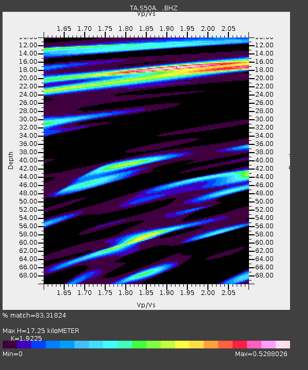
| Estimated Moho Depth: |
17.25 km |
| Estimated Crust Vp/Vs: |
1.92 |
| Assumed Crust Vp: |
6.476 km/s |
| Estimated Crust Vs: |
3.368 km/s |
| Estimated Crust Poisson's Ratio: |
0.31 |
|
| Radial Match: |
83.31824 % |
| Radial Bump: |
366 |
| Transverse Match: |
82.08992 % |
| Transverse Bump: |
400 |
| SOD ConfigId: |
626651 |
| Insert Time: |
2014-04-18 23:28:26.186 +0000 |
| GWidth: |
2.5 |
| Max Bumps: |
400 |
| Tol: |
0.001 |
|
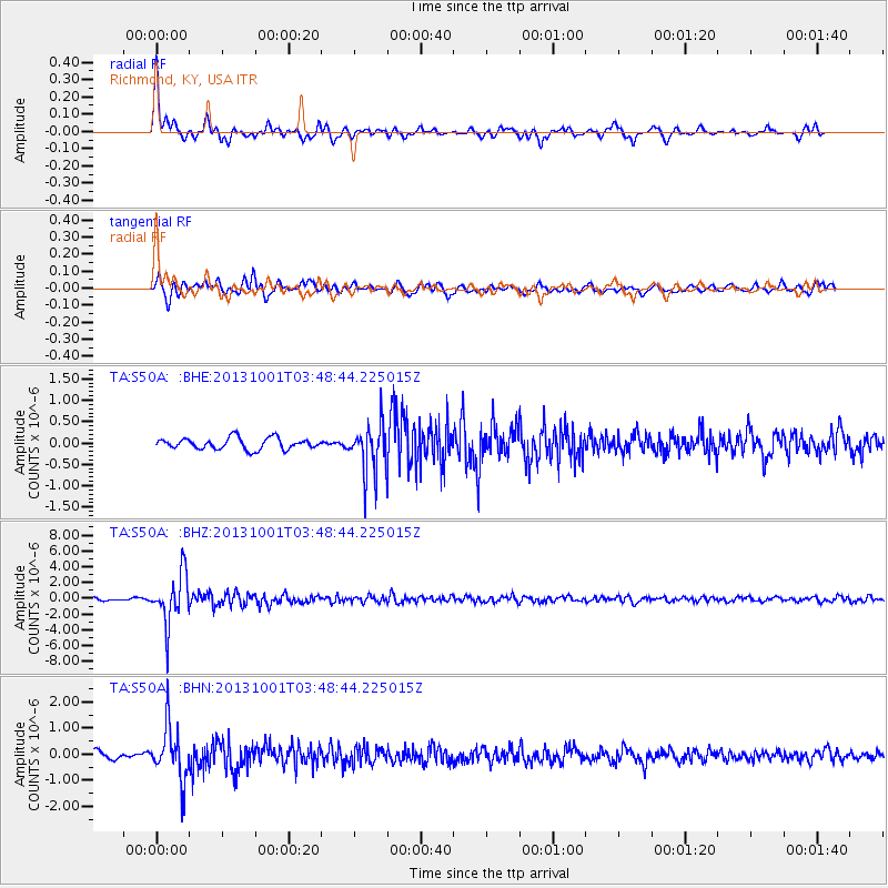
Signal To Noise
| Channel | StoN | STA | LTA |
| TA:S50A: :BHZ:20131001T03:48:44.225015Z | 19.285824 | 3.1825932E-6 | 1.6502241E-7 |
| TA:S50A: :BHN:20131001T03:48:44.225015Z | 7.678085 | 1.0190209E-6 | 1.3271811E-7 |
| TA:S50A: :BHE:20131001T03:48:44.225015Z | 4.494138 | 5.8771315E-7 | 1.3077327E-7 |
| Arrivals |
| Ps | 2.5 SECOND |
| PpPs | 7.6 SECOND |
| PsPs/PpSs | 10 SECOND |


