You are here: Home > Network List > TA - USArray Transportable Network (new EarthScope stations) Stations List
> Station T25A Trinidad, CO, USA > Earthquake Result Viewer
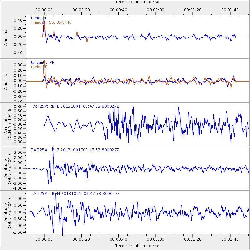
T25A Trinidad, CO, USA - Earthquake Result Viewer
*The percent match for this event was below the threshold and hence no stack was calculated.
| Earthquake location: |
Sea Of Okhotsk |
| Earthquake latitude/longitude: |
53.2/152.8 |
| Earthquake time(UTC): |
2013/10/01 (274) 03:38:21 GMT |
| Earthquake Depth: |
573 km |
| Earthquake Magnitude: |
6.7 MWW, 6.7 MWC, 6.8 MWC, 6.8 MWB |
| Earthquake Catalog/Contributor: |
NEIC PDE/NEIC COMCAT |
|
| Network: |
TA USArray Transportable Network (new EarthScope stations) |
| Station: |
T25A Trinidad, CO, USA |
| Lat/Lon: |
37.14 N/104.41 W |
| Elevation: |
2017 m |
|
| Distance: |
68.1 deg |
| Az: |
57.152 deg |
| Baz: |
320.767 deg |
| Ray Param: |
$rayparam |
*The percent match for this event was below the threshold and hence was not used in the summary stack. |
|
| Radial Match: |
58.546173 % |
| Radial Bump: |
400 |
| Transverse Match: |
44.20843 % |
| Transverse Bump: |
344 |
| SOD ConfigId: |
626651 |
| Insert Time: |
2014-04-18 23:29:01.817 +0000 |
| GWidth: |
2.5 |
| Max Bumps: |
400 |
| Tol: |
0.001 |
|
Signal To Noise
| Channel | StoN | STA | LTA |
| TA:T25A: :BHZ:20131001T03:47:53.800027Z | 11.920058 | 1.6285087E-6 | 1.3661919E-7 |
| TA:T25A: :BHN:20131001T03:47:53.800027Z | 1.7388396 | 3.6415847E-7 | 2.0942613E-7 |
| TA:T25A: :BHE:20131001T03:47:53.800027Z | 1.8624872 | 2.8179795E-7 | 1.5130195E-7 |
| Arrivals |
| Ps | |
| PpPs | |
| PsPs/PpSs | |


