You are here: Home > Network List > TA - USArray Transportable Network (new EarthScope stations) Stations List
> Station T54A Tazewell, VA, USA > Earthquake Result Viewer
T54A Tazewell, VA, USA - Earthquake Result Viewer
| Earthquake location: |
Sea Of Okhotsk |
| Earthquake latitude/longitude: |
53.2/152.8 |
| Earthquake time(UTC): |
2013/10/01 (274) 03:38:21 GMT |
| Earthquake Depth: |
573 km |
| Earthquake Magnitude: |
6.7 MWW, 6.7 MWC, 6.8 MWC, 6.8 MWB |
| Earthquake Catalog/Contributor: |
NEIC PDE/NEIC COMCAT |
|
| Network: |
TA USArray Transportable Network (new EarthScope stations) |
| Station: |
T54A Tazewell, VA, USA |
| Lat/Lon: |
37.06 N/81.58 W |
| Elevation: |
852 m |
|
| Distance: |
78.5 deg |
| Az: |
41.559 deg |
| Baz: |
330.072 deg |
| Ray Param: |
0.047811095 |
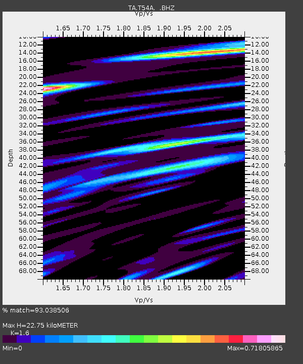
| Estimated Moho Depth: |
22.75 km |
| Estimated Crust Vp/Vs: |
1.60 |
| Assumed Crust Vp: |
6.159 km/s |
| Estimated Crust Vs: |
3.849 km/s |
| Estimated Crust Poisson's Ratio: |
0.18 |
|
| Radial Match: |
93.038506 % |
| Radial Bump: |
400 |
| Transverse Match: |
70.87596 % |
| Transverse Bump: |
400 |
| SOD ConfigId: |
626651 |
| Insert Time: |
2014-04-18 23:29:22.266 +0000 |
| GWidth: |
2.5 |
| Max Bumps: |
400 |
| Tol: |
0.001 |
|
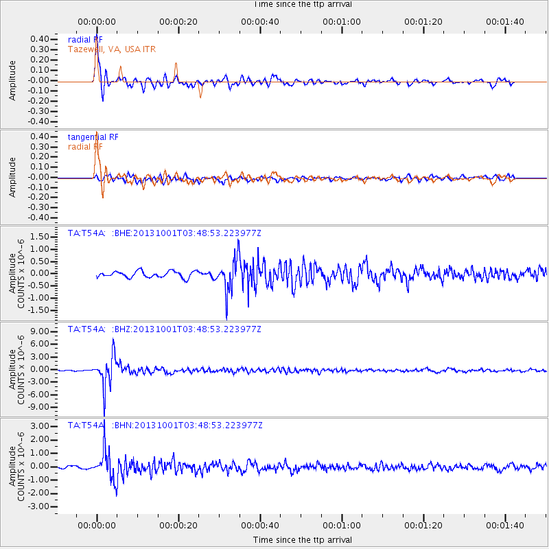
Signal To Noise
| Channel | StoN | STA | LTA |
| TA:T54A: :BHZ:20131001T03:48:53.223977Z | 18.273815 | 3.6750366E-6 | 2.0110943E-7 |
| TA:T54A: :BHN:20131001T03:48:53.223977Z | 11.943666 | 1.090464E-6 | 9.1300606E-8 |
| TA:T54A: :BHE:20131001T03:48:53.223977Z | 5.087821 | 6.6112676E-7 | 1.29943E-7 |
| Arrivals |
| Ps | 2.3 SECOND |
| PpPs | 9.3 SECOND |
| PsPs/PpSs | 12 SECOND |


