You are here: Home > Network List > TA - USArray Transportable Network (new EarthScope stations) Stations List
> Station T58A Grand View Acres, VA, USA > Earthquake Result Viewer
T58A Grand View Acres, VA, USA - Earthquake Result Viewer
| Earthquake location: |
Sea Of Okhotsk |
| Earthquake latitude/longitude: |
53.2/152.8 |
| Earthquake time(UTC): |
2013/10/01 (274) 03:38:21 GMT |
| Earthquake Depth: |
573 km |
| Earthquake Magnitude: |
6.7 MWW, 6.7 MWC, 6.8 MWC, 6.8 MWB |
| Earthquake Catalog/Contributor: |
NEIC PDE/NEIC COMCAT |
|
| Network: |
TA USArray Transportable Network (new EarthScope stations) |
| Station: |
T58A Grand View Acres, VA, USA |
| Lat/Lon: |
36.95 N/78.53 W |
| Elevation: |
167 m |
|
| Distance: |
79.8 deg |
| Az: |
39.452 deg |
| Baz: |
331.499 deg |
| Ray Param: |
0.046948496 |
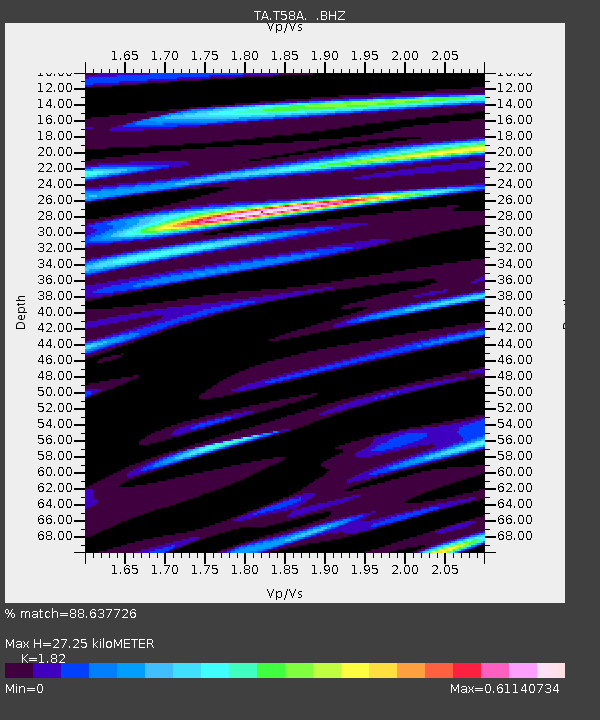
| Estimated Moho Depth: |
27.25 km |
| Estimated Crust Vp/Vs: |
1.82 |
| Assumed Crust Vp: |
6.419 km/s |
| Estimated Crust Vs: |
3.527 km/s |
| Estimated Crust Poisson's Ratio: |
0.28 |
|
| Radial Match: |
88.637726 % |
| Radial Bump: |
400 |
| Transverse Match: |
69.99482 % |
| Transverse Bump: |
400 |
| SOD ConfigId: |
626651 |
| Insert Time: |
2014-04-18 23:29:32.308 +0000 |
| GWidth: |
2.5 |
| Max Bumps: |
400 |
| Tol: |
0.001 |
|

Signal To Noise
| Channel | StoN | STA | LTA |
| TA:T58A: :BHZ:20131001T03:48:59.999978Z | 17.102686 | 2.9161374E-6 | 1.7050758E-7 |
| TA:T58A: :BHN:20131001T03:48:59.999978Z | 5.603058 | 8.97047E-7 | 1.6009955E-7 |
| TA:T58A: :BHE:20131001T03:48:59.999978Z | 4.4335446 | 6.143915E-7 | 1.3857796E-7 |
| Arrivals |
| Ps | 3.6 SECOND |
| PpPs | 12 SECOND |
| PsPs/PpSs | 15 SECOND |


