You are here: Home > Network List > TA - USArray Transportable Network (new EarthScope stations) Stations List
> Station TIGA Tifton, GA, USA > Earthquake Result Viewer
TIGA Tifton, GA, USA - Earthquake Result Viewer
| Earthquake location: |
Sea Of Okhotsk |
| Earthquake latitude/longitude: |
53.2/152.8 |
| Earthquake time(UTC): |
2013/10/01 (274) 03:38:21 GMT |
| Earthquake Depth: |
573 km |
| Earthquake Magnitude: |
6.7 MWW, 6.7 MWC, 6.8 MWC, 6.8 MWB |
| Earthquake Catalog/Contributor: |
NEIC PDE/NEIC COMCAT |
|
| Network: |
TA USArray Transportable Network (new EarthScope stations) |
| Station: |
TIGA Tifton, GA, USA |
| Lat/Lon: |
31.44 N/83.59 W |
| Elevation: |
109 m |
|
| Distance: |
82.5 deg |
| Az: |
45.875 deg |
| Baz: |
329.653 deg |
| Ray Param: |
0.04511324 |
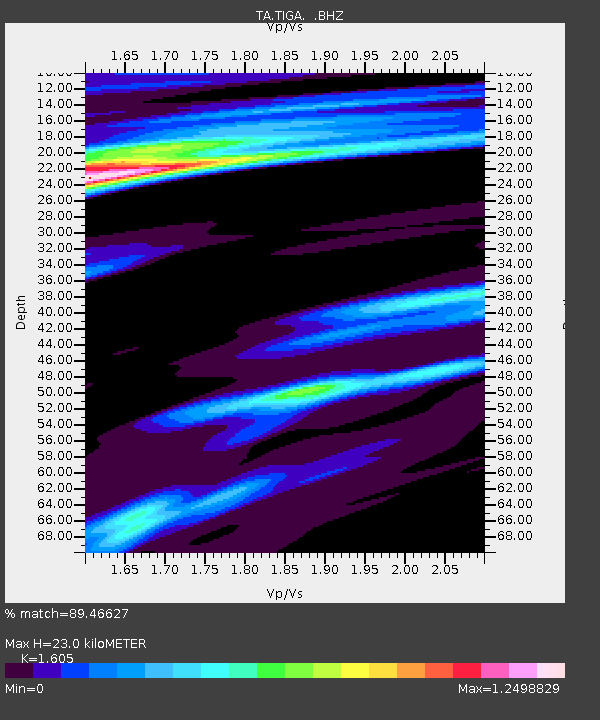
| Estimated Moho Depth: |
23.0 km |
| Estimated Crust Vp/Vs: |
1.61 |
| Assumed Crust Vp: |
6.565 km/s |
| Estimated Crust Vs: |
4.09 km/s |
| Estimated Crust Poisson's Ratio: |
0.18 |
|
| Radial Match: |
89.46627 % |
| Radial Bump: |
400 |
| Transverse Match: |
84.54552 % |
| Transverse Bump: |
400 |
| SOD ConfigId: |
626651 |
| Insert Time: |
2014-04-18 23:29:42.404 +0000 |
| GWidth: |
2.5 |
| Max Bumps: |
400 |
| Tol: |
0.001 |
|
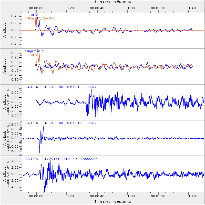
Signal To Noise
| Channel | StoN | STA | LTA |
| TA:TIGA: :BHZ:20131001T03:49:13.900002Z | 32.11108 | 6.313276E-6 | 1.9660742E-7 |
| TA:TIGA: :BHN:20131001T03:49:13.900002Z | 4.5262947 | 1.2484775E-6 | 2.7582772E-7 |
| TA:TIGA: :BHE:20131001T03:49:13.900002Z | 3.7251556 | 1.0786608E-6 | 2.895613E-7 |
| Arrivals |
| Ps | 2.2 SECOND |
| PpPs | 8.9 SECOND |
| PsPs/PpSs | 11 SECOND |


