You are here: Home > Network List > TA - USArray Transportable Network (new EarthScope stations) Stations List
> Station TPFO Pinon Flats, CA, USA > Earthquake Result Viewer
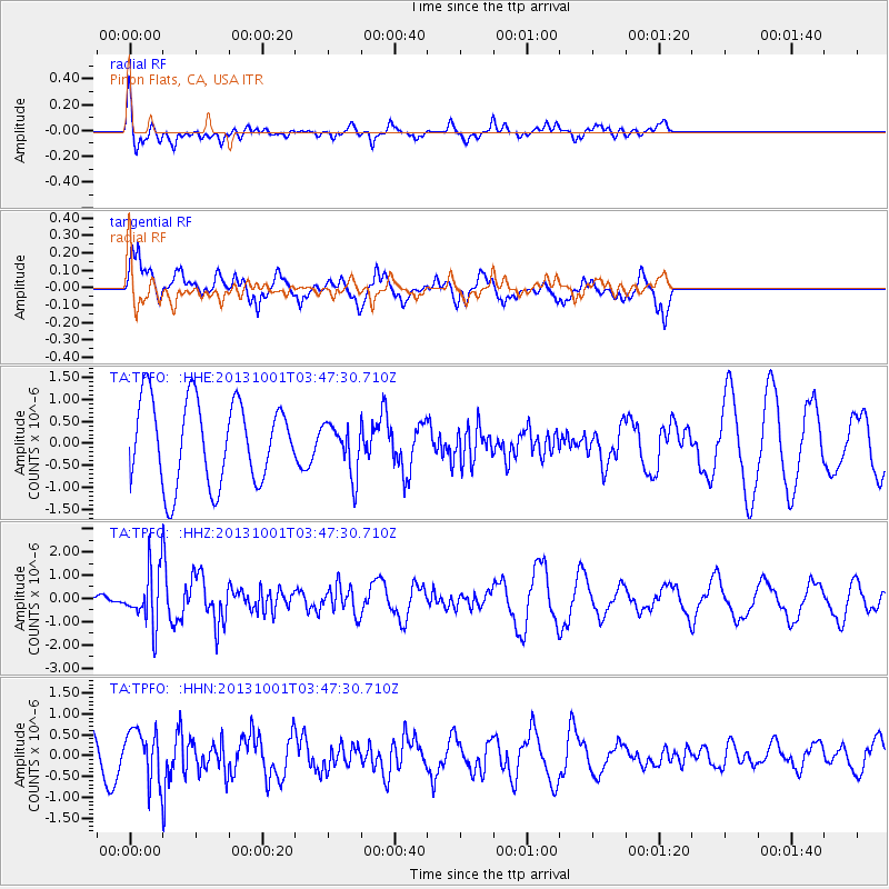
TPFO Pinon Flats, CA, USA - Earthquake Result Viewer
*The percent match for this event was below the threshold and hence no stack was calculated.
| Earthquake location: |
Sea Of Okhotsk |
| Earthquake latitude/longitude: |
53.2/152.8 |
| Earthquake time(UTC): |
2013/10/01 (274) 03:38:21 GMT |
| Earthquake Depth: |
573 km |
| Earthquake Magnitude: |
6.7 MWW, 6.7 MWC, 6.8 MWC, 6.8 MWB |
| Earthquake Catalog/Contributor: |
NEIC PDE/NEIC COMCAT |
|
| Network: |
TA USArray Transportable Network (new EarthScope stations) |
| Station: |
TPFO Pinon Flats, CA, USA |
| Lat/Lon: |
33.61 N/116.45 W |
| Elevation: |
1275 m |
|
| Distance: |
64.3 deg |
| Az: |
67.817 deg |
| Baz: |
318.125 deg |
| Ray Param: |
$rayparam |
*The percent match for this event was below the threshold and hence was not used in the summary stack. |
|
| Radial Match: |
67.59463 % |
| Radial Bump: |
332 |
| Transverse Match: |
67.77441 % |
| Transverse Bump: |
352 |
| SOD ConfigId: |
626651 |
| Insert Time: |
2014-04-18 23:29:46.910 +0000 |
| GWidth: |
2.5 |
| Max Bumps: |
400 |
| Tol: |
0.001 |
|
Signal To Noise
| Channel | StoN | STA | LTA |
| TA:TPFO: :HHZ:20131001T03:47:30.710Z | 2.6351066 | 1.1616667E-6 | 4.408424E-7 |
| TA:TPFO: :HHN:20131001T03:47:30.710Z | 1.3877718 | 5.908723E-7 | 4.2577048E-7 |
| TA:TPFO: :HHE:20131001T03:47:30.710Z | 0.6061535 | 5.73622E-7 | 9.4633134E-7 |
| Arrivals |
| Ps | |
| PpPs | |
| PsPs/PpSs | |


