You are here: Home > Network List > TA - USArray Transportable Network (new EarthScope stations) Stations List
> Station U51A La Follette, TN, USA > Earthquake Result Viewer
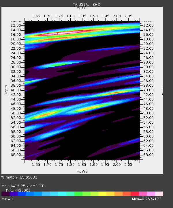
U51A La Follette, TN, USA - Earthquake Result Viewer
| Earthquake location: |
Sea Of Okhotsk |
| Earthquake latitude/longitude: |
53.2/152.8 |
| Earthquake time(UTC): |
2013/10/01 (274) 03:38:21 GMT |
| Earthquake Depth: |
573 km |
| Earthquake Magnitude: |
6.7 MWW, 6.7 MWC, 6.8 MWC, 6.8 MWB |
| Earthquake Catalog/Contributor: |
NEIC PDE/NEIC COMCAT |
|
| Network: |
TA USArray Transportable Network (new EarthScope stations) |
| Station: |
U51A La Follette, TN, USA |
| Lat/Lon: |
36.38 N/84.02 W |
| Elevation: |
472 m |
|
| Distance: |
78.1 deg |
| Az: |
43.637 deg |
| Baz: |
329.04 deg |
| Ray Param: |
0.048078302 |
| Estimated Moho Depth: |
15.25 km |
| Estimated Crust Vp/Vs: |
1.74 |
| Assumed Crust Vp: |
6.476 km/s |
| Estimated Crust Vs: |
3.716 km/s |
| Estimated Crust Poisson's Ratio: |
0.25 |
|
| Radial Match: |
85.05683 % |
| Radial Bump: |
400 |
| Transverse Match: |
77.10206 % |
| Transverse Bump: |
400 |
| SOD ConfigId: |
626651 |
| Insert Time: |
2014-04-18 23:29:59.308 +0000 |
| GWidth: |
2.5 |
| Max Bumps: |
400 |
| Tol: |
0.001 |
|

Signal To Noise
| Channel | StoN | STA | LTA |
| TA:U51A: :BHZ:20131001T03:48:51.050027Z | 10.756472 | 2.8028326E-6 | 2.6057177E-7 |
| TA:U51A: :BHN:20131001T03:48:51.050027Z | 12.729382 | 1.813444E-6 | 1.4246127E-7 |
| TA:U51A: :BHE:20131001T03:48:51.050027Z | 7.748855 | 1.0189485E-6 | 1.3149665E-7 |
| Arrivals |
| Ps | 1.8 SECOND |
| PpPs | 6.3 SECOND |
| PsPs/PpSs | 8.1 SECOND |


