You are here: Home > Network List > TA - USArray Transportable Network (new EarthScope stations) Stations List
> Station U53A Fall Branch, TN, USA > Earthquake Result Viewer
U53A Fall Branch, TN, USA - Earthquake Result Viewer
| Earthquake location: |
Sea Of Okhotsk |
| Earthquake latitude/longitude: |
53.2/152.8 |
| Earthquake time(UTC): |
2013/10/01 (274) 03:38:21 GMT |
| Earthquake Depth: |
573 km |
| Earthquake Magnitude: |
6.7 MWW, 6.7 MWC, 6.8 MWC, 6.8 MWB |
| Earthquake Catalog/Contributor: |
NEIC PDE/NEIC COMCAT |
|
| Network: |
TA USArray Transportable Network (new EarthScope stations) |
| Station: |
U53A Fall Branch, TN, USA |
| Lat/Lon: |
36.36 N/82.58 W |
| Elevation: |
559 m |
|
| Distance: |
78.7 deg |
| Az: |
42.624 deg |
| Baz: |
329.687 deg |
| Ray Param: |
0.04767839 |
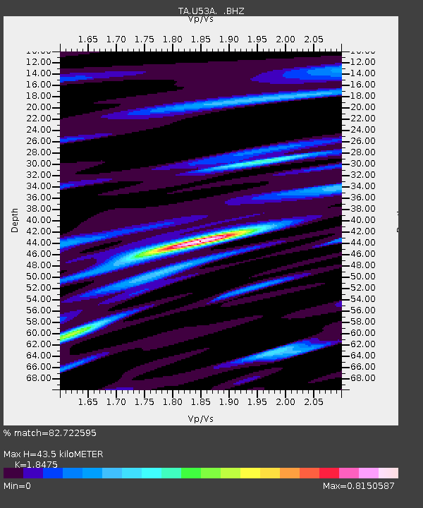
| Estimated Moho Depth: |
43.5 km |
| Estimated Crust Vp/Vs: |
1.85 |
| Assumed Crust Vp: |
6.476 km/s |
| Estimated Crust Vs: |
3.505 km/s |
| Estimated Crust Poisson's Ratio: |
0.29 |
|
| Radial Match: |
82.722595 % |
| Radial Bump: |
400 |
| Transverse Match: |
83.52862 % |
| Transverse Bump: |
400 |
| SOD ConfigId: |
626651 |
| Insert Time: |
2014-04-18 23:30:04.800 +0000 |
| GWidth: |
2.5 |
| Max Bumps: |
400 |
| Tol: |
0.001 |
|
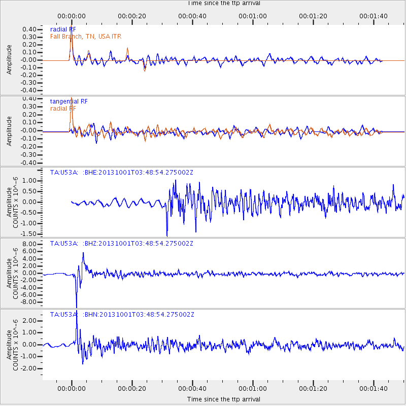
Signal To Noise
| Channel | StoN | STA | LTA |
| TA:U53A: :BHZ:20131001T03:48:54.275002Z | 27.10677 | 2.9166392E-6 | 1.0759818E-7 |
| TA:U53A: :BHN:20131001T03:48:54.275002Z | 6.736328 | 8.48852E-7 | 1.2601107E-7 |
| TA:U53A: :BHE:20131001T03:48:54.275002Z | 4.9076552 | 4.918127E-7 | 1.00213384E-7 |
| Arrivals |
| Ps | 5.8 SECOND |
| PpPs | 19 SECOND |
| PsPs/PpSs | 24 SECOND |


