You are here: Home > Network List > TA - USArray Transportable Network (new EarthScope stations) Stations List
> Station V48A Smith Brothers Farm, Spring Hill, TN, USA > Earthquake Result Viewer
V48A Smith Brothers Farm, Spring Hill, TN, USA - Earthquake Result Viewer
| Earthquake location: |
Sea Of Okhotsk |
| Earthquake latitude/longitude: |
53.2/152.8 |
| Earthquake time(UTC): |
2013/10/01 (274) 03:38:21 GMT |
| Earthquake Depth: |
573 km |
| Earthquake Magnitude: |
6.7 MWW, 6.7 MWC, 6.8 MWC, 6.8 MWB |
| Earthquake Catalog/Contributor: |
NEIC PDE/NEIC COMCAT |
|
| Network: |
TA USArray Transportable Network (new EarthScope stations) |
| Station: |
V48A Smith Brothers Farm, Spring Hill, TN, USA |
| Lat/Lon: |
35.74 N/86.82 W |
| Elevation: |
278 m |
|
| Distance: |
77.5 deg |
| Az: |
45.96 deg |
| Baz: |
327.887 deg |
| Ray Param: |
0.048498683 |
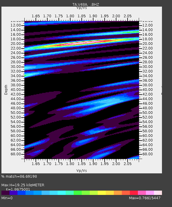
| Estimated Moho Depth: |
19.25 km |
| Estimated Crust Vp/Vs: |
1.87 |
| Assumed Crust Vp: |
6.476 km/s |
| Estimated Crust Vs: |
3.468 km/s |
| Estimated Crust Poisson's Ratio: |
0.30 |
|
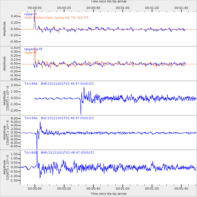
| Radial Match: |
86.69198 % |
| Radial Bump: |
400 |
| Transverse Match: |
73.62146 % |
| Transverse Bump: |
400 |
| SOD ConfigId: |
626651 |
| Insert Time: |
2014-04-18 23:30:28.119 +0000 |
| GWidth: |
2.5 |
| Max Bumps: |
400 |
| Tol: |
0.001 |
|
Signal To Noise
| Channel | StoN | STA | LTA |
| TA:V48A: :BHZ:20131001T03:48:47.600015Z | 19.38856 | 2.939602E-6 | 1.5161528E-7 |
| TA:V48A: :BHN:20131001T03:48:47.600015Z | 6.192941 | 6.2725695E-7 | 1.012858E-7 |
| TA:V48A: :BHE:20131001T03:48:47.600015Z | 9.242539 | 7.7664333E-7 | 8.402922E-8 |
| Arrivals |
| Ps | 2.7 SECOND |
| PpPs | 8.3 SECOND |
| PsPs/PpSs | 11 SECOND |


