You are here: Home > Network List > TA - USArray Transportable Network (new EarthScope stations) Stations List
> Station V57A Coltrane Farms, NC, USA > Earthquake Result Viewer
V57A Coltrane Farms, NC, USA - Earthquake Result Viewer

| Earthquake location: |
Sea Of Okhotsk |
| Earthquake latitude/longitude: |
53.2/152.8 |
| Earthquake time(UTC): |
2013/10/01 (274) 03:38:21 GMT |
| Earthquake Depth: |
573 km |
| Earthquake Magnitude: |
6.7 MWW, 6.7 MWC, 6.8 MWC, 6.8 MWB |
| Earthquake Catalog/Contributor: |
NEIC PDE/NEIC COMCAT |
|
| Network: |
TA USArray Transportable Network (new EarthScope stations) |
| Station: |
V57A Coltrane Farms, NC, USA |
| Lat/Lon: |
35.89 N/79.78 W |
| Elevation: |
223 m |
|
| Distance: |
80.3 deg |
| Az: |
40.859 deg |
| Baz: |
331.009 deg |
| Ray Param: |
0.046654012 |
| Estimated Moho Depth: |
41.0 km |
| Estimated Crust Vp/Vs: |
1.64 |
| Assumed Crust Vp: |
6.565 km/s |
| Estimated Crust Vs: |
3.997 km/s |
| Estimated Crust Poisson's Ratio: |
0.21 |
|
| Radial Match: |
89.831314 % |
| Radial Bump: |
400 |
| Transverse Match: |
83.64218 % |
| Transverse Bump: |
400 |
| SOD ConfigId: |
626651 |
| Insert Time: |
2014-04-18 23:30:53.846 +0000 |
| GWidth: |
2.5 |
| Max Bumps: |
400 |
| Tol: |
0.001 |
|
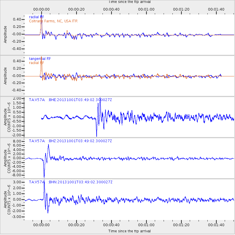
Signal To Noise
| Channel | StoN | STA | LTA |
| TA:V57A: :BHZ:20131001T03:49:02.300027Z | 24.91874 | 3.3122155E-6 | 1.3292066E-7 |
| TA:V57A: :BHN:20131001T03:49:02.300027Z | 13.160123 | 1.1961423E-6 | 9.0891426E-8 |
| TA:V57A: :BHE:20131001T03:49:02.300027Z | 7.496048 | 8.279773E-7 | 1.1045518E-7 |
| Arrivals |
| Ps | 4.1 SECOND |
| PpPs | 16 SECOND |
| PsPs/PpSs | 20 SECOND |


