You are here: Home > Network List > TA - USArray Transportable Network (new EarthScope stations) Stations List
> Station V59A Middlesex, NC, USA > Earthquake Result Viewer
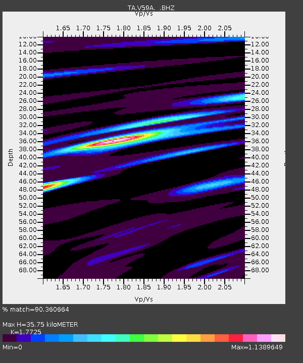
V59A Middlesex, NC, USA - Earthquake Result Viewer
| Earthquake location: |
Sea Of Okhotsk |
| Earthquake latitude/longitude: |
53.2/152.8 |
| Earthquake time(UTC): |
2013/10/01 (274) 03:38:21 GMT |
| Earthquake Depth: |
573 km |
| Earthquake Magnitude: |
6.7 MWW, 6.7 MWC, 6.8 MWC, 6.8 MWB |
| Earthquake Catalog/Contributor: |
NEIC PDE/NEIC COMCAT |
|
| Network: |
TA USArray Transportable Network (new EarthScope stations) |
| Station: |
V59A Middlesex, NC, USA |
| Lat/Lon: |
35.76 N/78.24 W |
| Elevation: |
58 m |
|
| Distance: |
81.0 deg |
| Az: |
39.808 deg |
| Baz: |
331.733 deg |
| Ray Param: |
0.046181258 |
| Estimated Moho Depth: |
35.75 km |
| Estimated Crust Vp/Vs: |
1.77 |
| Assumed Crust Vp: |
6.565 km/s |
| Estimated Crust Vs: |
3.704 km/s |
| Estimated Crust Poisson's Ratio: |
0.27 |
|
| Radial Match: |
90.360664 % |
| Radial Bump: |
400 |
| Transverse Match: |
84.536156 % |
| Transverse Bump: |
400 |
| SOD ConfigId: |
626651 |
| Insert Time: |
2014-04-18 23:31:02.048 +0000 |
| GWidth: |
2.5 |
| Max Bumps: |
400 |
| Tol: |
0.001 |
|

Signal To Noise
| Channel | StoN | STA | LTA |
| TA:V59A: :BHZ:20131001T03:49:05.925027Z | 23.819235 | 3.2625248E-6 | 1.3697019E-7 |
| TA:V59A: :BHN:20131001T03:49:05.925027Z | 10.442087 | 1.103898E-6 | 1.0571622E-7 |
| TA:V59A: :BHE:20131001T03:49:05.925027Z | 9.06993 | 1.0207071E-6 | 1.12537485E-7 |
| Arrivals |
| Ps | 4.3 SECOND |
| PpPs | 15 SECOND |
| PsPs/PpSs | 19 SECOND |


