You are here: Home > Network List > TA - USArray Transportable Network (new EarthScope stations) Stations List
> Station V62A Hyde County Airport, Englehard, NC, USA > Earthquake Result Viewer
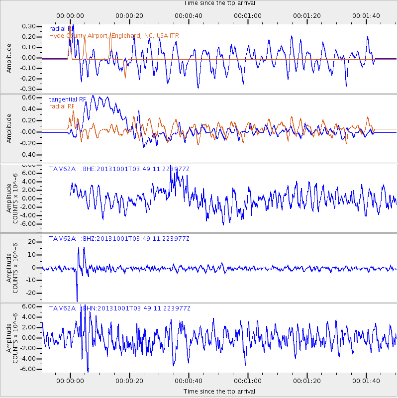
V62A Hyde County Airport, Englehard, NC, USA - Earthquake Result Viewer
*The percent match for this event was below the threshold and hence no stack was calculated.
| Earthquake location: |
Sea Of Okhotsk |
| Earthquake latitude/longitude: |
53.2/152.8 |
| Earthquake time(UTC): |
2013/10/01 (274) 03:38:21 GMT |
| Earthquake Depth: |
573 km |
| Earthquake Magnitude: |
6.7 MWW, 6.7 MWC, 6.8 MWC, 6.8 MWB |
| Earthquake Catalog/Contributor: |
NEIC PDE/NEIC COMCAT |
|
| Network: |
TA USArray Transportable Network (new EarthScope stations) |
| Station: |
V62A Hyde County Airport, Englehard, NC, USA |
| Lat/Lon: |
35.56 N/75.96 W |
| Elevation: |
-3.0 m |
|
| Distance: |
82.0 deg |
| Az: |
38.24 deg |
| Baz: |
332.825 deg |
| Ray Param: |
$rayparam |
*The percent match for this event was below the threshold and hence was not used in the summary stack. |
|
| Radial Match: |
60.93139 % |
| Radial Bump: |
400 |
| Transverse Match: |
42.041534 % |
| Transverse Bump: |
400 |
| SOD ConfigId: |
626651 |
| Insert Time: |
2014-04-18 23:31:14.445 +0000 |
| GWidth: |
2.5 |
| Max Bumps: |
400 |
| Tol: |
0.001 |
|
Signal To Noise
| Channel | StoN | STA | LTA |
| TA:V62A: :BHZ:20131001T03:49:11.223977Z | 6.266249 | 7.745454E-6 | 1.236059E-6 |
| TA:V62A: :BHN:20131001T03:49:11.223977Z | 1.5736216 | 1.9608703E-6 | 1.2460877E-6 |
| TA:V62A: :BHE:20131001T03:49:11.223977Z | 1.4259455 | 2.6201556E-6 | 1.8374865E-6 |
| Arrivals |
| Ps | |
| PpPs | |
| PsPs/PpSs | |


