You are here: Home > Network List > TA - USArray Transportable Network (new EarthScope stations) Stations List
> Station W61A Ground Anchor Farm, New Bern, NC, USA > Earthquake Result Viewer
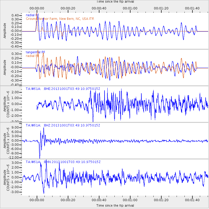
W61A Ground Anchor Farm, New Bern, NC, USA - Earthquake Result Viewer
*The percent match for this event was below the threshold and hence no stack was calculated.
| Earthquake location: |
Sea Of Okhotsk |
| Earthquake latitude/longitude: |
53.2/152.8 |
| Earthquake time(UTC): |
2013/10/01 (274) 03:38:21 GMT |
| Earthquake Depth: |
573 km |
| Earthquake Magnitude: |
6.7 MWW, 6.7 MWC, 6.8 MWC, 6.8 MWB |
| Earthquake Catalog/Contributor: |
NEIC PDE/NEIC COMCAT |
|
| Network: |
TA USArray Transportable Network (new EarthScope stations) |
| Station: |
W61A Ground Anchor Farm, New Bern, NC, USA |
| Lat/Lon: |
35.18 N/76.99 W |
| Elevation: |
6.0 m |
|
| Distance: |
82.0 deg |
| Az: |
39.175 deg |
| Baz: |
332.36 deg |
| Ray Param: |
$rayparam |
*The percent match for this event was below the threshold and hence was not used in the summary stack. |
|
| Radial Match: |
63.937515 % |
| Radial Bump: |
400 |
| Transverse Match: |
67.51421 % |
| Transverse Bump: |
400 |
| SOD ConfigId: |
626651 |
| Insert Time: |
2014-04-18 23:31:52.286 +0000 |
| GWidth: |
2.5 |
| Max Bumps: |
400 |
| Tol: |
0.001 |
|
Signal To Noise
| Channel | StoN | STA | LTA |
| TA:W61A: :BHZ:20131001T03:49:10.975015Z | 18.6381 | 4.409892E-6 | 2.366063E-7 |
| TA:W61A: :BHN:20131001T03:49:10.975015Z | 4.1829543 | 1.4793136E-6 | 3.536528E-7 |
| TA:W61A: :BHE:20131001T03:49:10.975015Z | 1.8150206 | 8.998684E-7 | 4.9578966E-7 |
| Arrivals |
| Ps | |
| PpPs | |
| PsPs/PpSs | |


