You are here: Home > Network List > TA - USArray Transportable Network (new EarthScope stations) Stations List
> Station X52A Dahlonega, GA, USA > Earthquake Result Viewer
X52A Dahlonega, GA, USA - Earthquake Result Viewer
| Earthquake location: |
Sea Of Okhotsk |
| Earthquake latitude/longitude: |
53.2/152.8 |
| Earthquake time(UTC): |
2013/10/01 (274) 03:38:21 GMT |
| Earthquake Depth: |
573 km |
| Earthquake Magnitude: |
6.7 MWW, 6.7 MWC, 6.8 MWC, 6.8 MWB |
| Earthquake Catalog/Contributor: |
NEIC PDE/NEIC COMCAT |
|
| Network: |
TA USArray Transportable Network (new EarthScope stations) |
| Station: |
X52A Dahlonega, GA, USA |
| Lat/Lon: |
34.60 N/83.89 W |
| Elevation: |
481 m |
|
| Distance: |
79.7 deg |
| Az: |
44.475 deg |
| Baz: |
329.272 deg |
| Ray Param: |
0.047030415 |
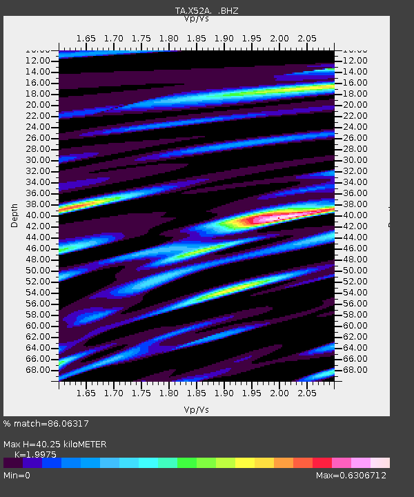
| Estimated Moho Depth: |
40.25 km |
| Estimated Crust Vp/Vs: |
2.00 |
| Assumed Crust Vp: |
6.35 km/s |
| Estimated Crust Vs: |
3.179 km/s |
| Estimated Crust Poisson's Ratio: |
0.33 |
|
| Radial Match: |
86.06317 % |
| Radial Bump: |
400 |
| Transverse Match: |
75.1612 % |
| Transverse Bump: |
400 |
| SOD ConfigId: |
626651 |
| Insert Time: |
2014-04-18 23:32:08.385 +0000 |
| GWidth: |
2.5 |
| Max Bumps: |
400 |
| Tol: |
0.001 |
|

Signal To Noise
| Channel | StoN | STA | LTA |
| TA:X52A: :BHZ:20131001T03:48:59.348977Z | 25.250622 | 2.738673E-6 | 1.08459616E-7 |
| TA:X52A: :BHN:20131001T03:48:59.348977Z | 8.4528475 | 9.0765616E-7 | 1.0737875E-7 |
| TA:X52A: :BHE:20131001T03:48:59.348977Z | 6.941256 | 6.7956034E-7 | 9.790164E-8 |
| Arrivals |
| Ps | 6.5 SECOND |
| PpPs | 19 SECOND |
| PsPs/PpSs | 25 SECOND |


