You are here: Home > Network List > TA - USArray Transportable Network (new EarthScope stations) Stations List
> Station Y60A Bolivia, NC, USA > Earthquake Result Viewer
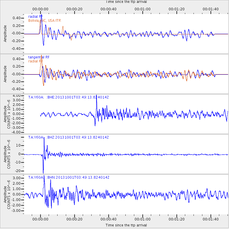
Y60A Bolivia, NC, USA - Earthquake Result Viewer
*The percent match for this event was below the threshold and hence no stack was calculated.
| Earthquake location: |
Sea Of Okhotsk |
| Earthquake latitude/longitude: |
53.2/152.8 |
| Earthquake time(UTC): |
2013/10/01 (274) 03:38:21 GMT |
| Earthquake Depth: |
573 km |
| Earthquake Magnitude: |
6.7 MWW, 6.7 MWC, 6.8 MWC, 6.8 MWB |
| Earthquake Catalog/Contributor: |
NEIC PDE/NEIC COMCAT |
|
| Network: |
TA USArray Transportable Network (new EarthScope stations) |
| Station: |
Y60A Bolivia, NC, USA |
| Lat/Lon: |
34.00 N/78.22 W |
| Elevation: |
7.0 m |
|
| Distance: |
82.5 deg |
| Az: |
40.629 deg |
| Baz: |
331.864 deg |
| Ray Param: |
$rayparam |
*The percent match for this event was below the threshold and hence was not used in the summary stack. |
|
| Radial Match: |
78.02685 % |
| Radial Bump: |
400 |
| Transverse Match: |
70.43409 % |
| Transverse Bump: |
400 |
| SOD ConfigId: |
626651 |
| Insert Time: |
2014-04-18 23:33:11.040 +0000 |
| GWidth: |
2.5 |
| Max Bumps: |
400 |
| Tol: |
0.001 |
|
Signal To Noise
| Channel | StoN | STA | LTA |
| TA:Y60A: :BHZ:20131001T03:49:13.824014Z | 50.757565 | 7.144097E-6 | 1.407494E-7 |
| TA:Y60A: :BHN:20131001T03:49:13.824014Z | 3.88445 | 1.2906737E-6 | 3.3226678E-7 |
| TA:Y60A: :BHE:20131001T03:49:13.824014Z | 4.3816457 | 1.1347727E-6 | 2.589832E-7 |
| Arrivals |
| Ps | |
| PpPs | |
| PsPs/PpSs | |


