You are here: Home > Network List > TA - USArray Transportable Network (new EarthScope stations) Stations List
> Station Z55A Blythe, GA, USA > Earthquake Result Viewer
Z55A Blythe, GA, USA - Earthquake Result Viewer
| Earthquake location: |
Sea Of Okhotsk |
| Earthquake latitude/longitude: |
53.2/152.8 |
| Earthquake time(UTC): |
2013/10/01 (274) 03:38:21 GMT |
| Earthquake Depth: |
573 km |
| Earthquake Magnitude: |
6.7 MWW, 6.7 MWC, 6.8 MWC, 6.8 MWB |
| Earthquake Catalog/Contributor: |
NEIC PDE/NEIC COMCAT |
|
| Network: |
TA USArray Transportable Network (new EarthScope stations) |
| Station: |
Z55A Blythe, GA, USA |
| Lat/Lon: |
33.22 N/82.14 W |
| Elevation: |
100 m |
|
| Distance: |
81.6 deg |
| Az: |
43.9 deg |
| Baz: |
330.155 deg |
| Ray Param: |
0.04573766 |
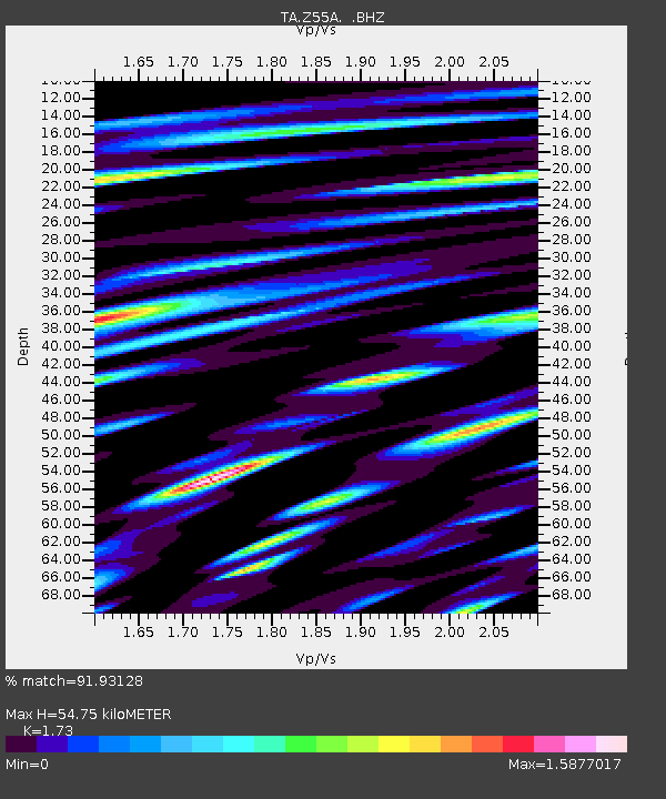
| Estimated Moho Depth: |
54.75 km |
| Estimated Crust Vp/Vs: |
1.73 |
| Assumed Crust Vp: |
6.565 km/s |
| Estimated Crust Vs: |
3.795 km/s |
| Estimated Crust Poisson's Ratio: |
0.25 |
|
| Radial Match: |
91.93128 % |
| Radial Bump: |
400 |
| Transverse Match: |
86.72524 % |
| Transverse Bump: |
400 |
| SOD ConfigId: |
626651 |
| Insert Time: |
2014-04-18 23:33:29.100 +0000 |
| GWidth: |
2.5 |
| Max Bumps: |
400 |
| Tol: |
0.001 |
|
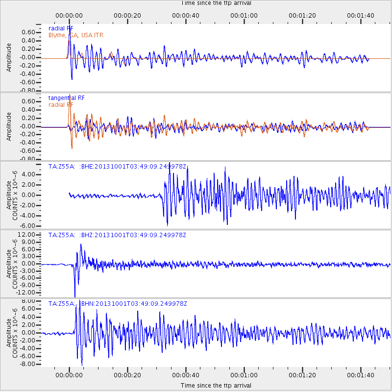
Signal To Noise
| Channel | StoN | STA | LTA |
| TA:Z55A: :BHZ:20131001T03:49:09.249978Z | 33.87059 | 4.150071E-6 | 1.2252728E-7 |
| TA:Z55A: :BHN:20131001T03:49:09.249978Z | 23.215113 | 3.4961868E-6 | 1.505996E-7 |
| TA:Z55A: :BHE:20131001T03:49:09.249978Z | 13.2753725 | 2.3182338E-6 | 1.7462665E-7 |
| Arrivals |
| Ps | 6.3 SECOND |
| PpPs | 22 SECOND |
| PsPs/PpSs | 28 SECOND |


