You are here: Home > Network List > TA - USArray Transportable Network (new EarthScope stations) Stations List
> Station Z54A Sparta, GA, USA > Earthquake Result Viewer
Z54A Sparta, GA, USA - Earthquake Result Viewer
| Earthquake location: |
Sea Of Okhotsk |
| Earthquake latitude/longitude: |
53.2/152.8 |
| Earthquake time(UTC): |
2013/10/01 (274) 03:38:21 GMT |
| Earthquake Depth: |
573 km |
| Earthquake Magnitude: |
6.7 MWW, 6.7 MWC, 6.8 MWC, 6.8 MWB |
| Earthquake Catalog/Contributor: |
NEIC PDE/NEIC COMCAT |
|
| Network: |
TA USArray Transportable Network (new EarthScope stations) |
| Station: |
Z54A Sparta, GA, USA |
| Lat/Lon: |
33.24 N/82.84 W |
| Elevation: |
134 m |
|
| Distance: |
81.3 deg |
| Az: |
44.41 deg |
| Baz: |
329.846 deg |
| Ray Param: |
0.045945954 |
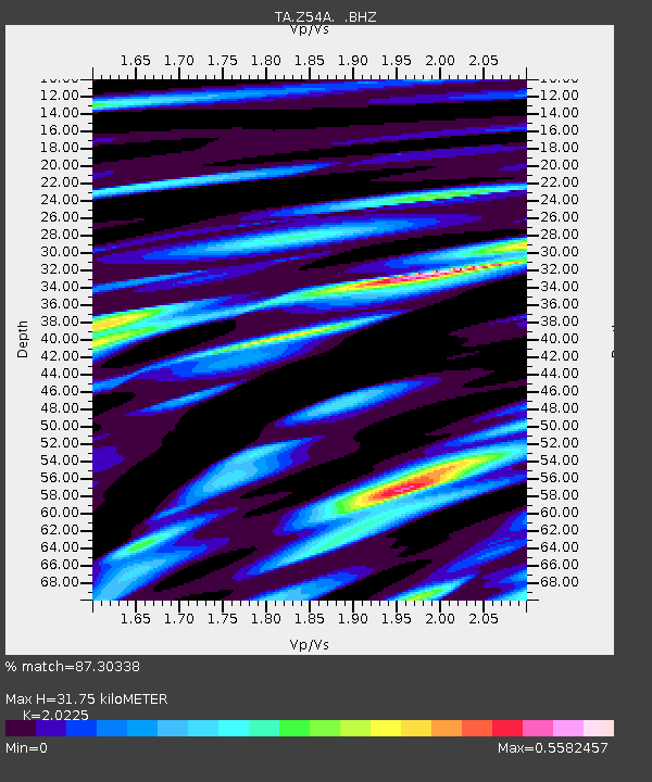
| Estimated Moho Depth: |
31.75 km |
| Estimated Crust Vp/Vs: |
2.02 |
| Assumed Crust Vp: |
6.565 km/s |
| Estimated Crust Vs: |
3.246 km/s |
| Estimated Crust Poisson's Ratio: |
0.34 |
|
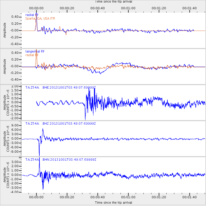
| Radial Match: |
87.30338 % |
| Radial Bump: |
400 |
| Transverse Match: |
55.61545 % |
| Transverse Bump: |
400 |
| SOD ConfigId: |
626651 |
| Insert Time: |
2014-04-18 23:33:29.775 +0000 |
| GWidth: |
2.5 |
| Max Bumps: |
400 |
| Tol: |
0.001 |
|
Signal To Noise
| Channel | StoN | STA | LTA |
| TA:Z54A: :BHZ:20131001T03:49:07.69999Z | 27.750854 | 3.5493945E-6 | 1.2790217E-7 |
| TA:Z54A: :BHN:20131001T03:49:07.69999Z | 15.399369 | 1.2005133E-6 | 7.79586E-8 |
| TA:Z54A: :BHE:20131001T03:49:07.69999Z | 5.182292 | 7.93757E-7 | 1.5316718E-7 |
| Arrivals |
| Ps | 5.1 SECOND |
| PpPs | 14 SECOND |
| PsPs/PpSs | 19 SECOND |


