You are here: Home > Network List > US - United States National Seismic Network Stations List
> Station BW06 Boulder Array Site 6 (Pinedale), Wyoming, USA > Earthquake Result Viewer
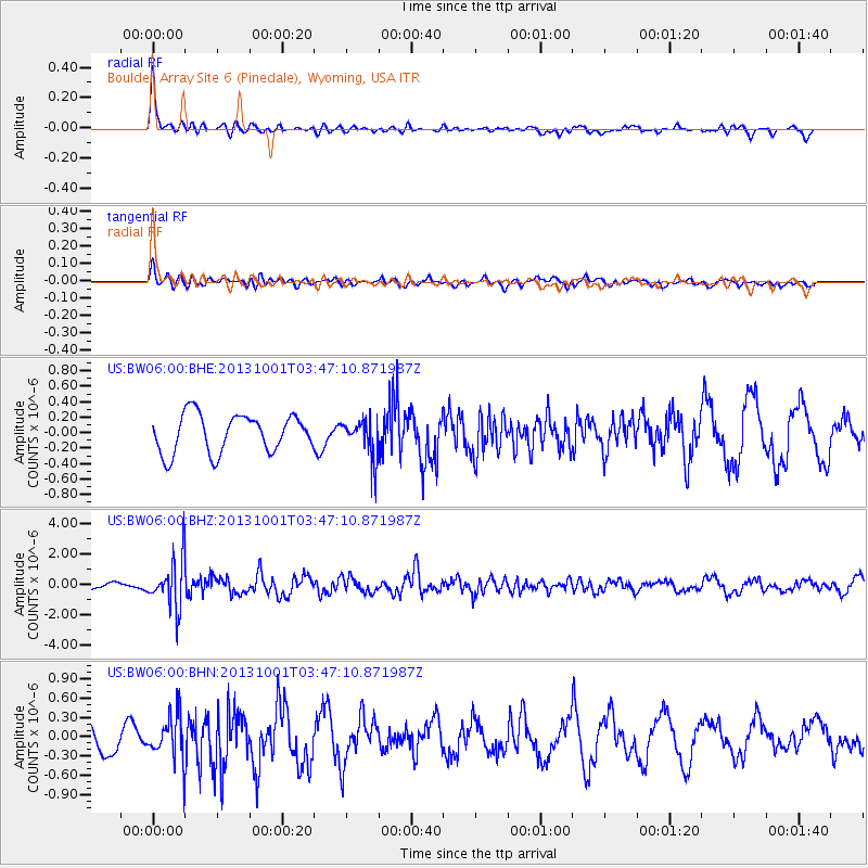
BW06 Boulder Array Site 6 (Pinedale), Wyoming, USA - Earthquake Result Viewer
*The percent match for this event was below the threshold and hence no stack was calculated.
| Earthquake location: |
Sea Of Okhotsk |
| Earthquake latitude/longitude: |
53.2/152.8 |
| Earthquake time(UTC): |
2013/10/01 (274) 03:38:21 GMT |
| Earthquake Depth: |
573 km |
| Earthquake Magnitude: |
6.7 MWW, 6.7 MWC, 6.8 MWC, 6.8 MWB |
| Earthquake Catalog/Contributor: |
NEIC PDE/NEIC COMCAT |
|
| Network: |
US United States National Seismic Network |
| Station: |
BW06 Boulder Array Site 6 (Pinedale), Wyoming, USA |
| Lat/Lon: |
42.77 N/109.56 W |
| Elevation: |
2224 m |
|
| Distance: |
61.2 deg |
| Az: |
56.374 deg |
| Baz: |
317.136 deg |
| Ray Param: |
$rayparam |
*The percent match for this event was below the threshold and hence was not used in the summary stack. |
|
| Radial Match: |
72.583084 % |
| Radial Bump: |
370 |
| Transverse Match: |
38.2703 % |
| Transverse Bump: |
397 |
| SOD ConfigId: |
626651 |
| Insert Time: |
2014-04-18 23:34:38.855 +0000 |
| GWidth: |
2.5 |
| Max Bumps: |
400 |
| Tol: |
0.001 |
|
Signal To Noise
| Channel | StoN | STA | LTA |
| US:BW06:00:BHZ:20131001T03:47:10.871987Z | 4.8939886 | 1.6147962E-6 | 3.2995507E-7 |
| US:BW06:00:BHN:20131001T03:47:10.871987Z | 1.3665555 | 3.5163848E-7 | 2.573174E-7 |
| US:BW06:00:BHE:20131001T03:47:10.871987Z | 1.0214007 | 2.5106098E-7 | 2.458007E-7 |
| Arrivals |
| Ps | |
| PpPs | |
| PsPs/PpSs | |


