You are here: Home > Network List > US - United States National Seismic Network Stations List
> Station MSO Missoula, Montana, USA > Earthquake Result Viewer
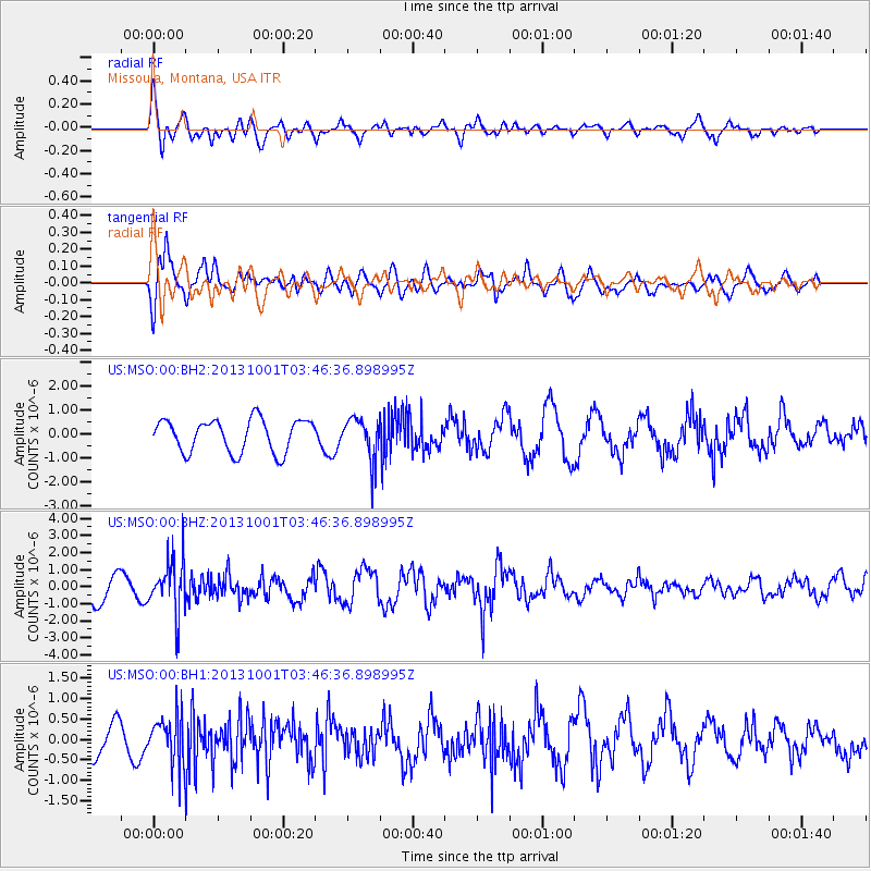
MSO Missoula, Montana, USA - Earthquake Result Viewer
*The percent match for this event was below the threshold and hence no stack was calculated.
| Earthquake location: |
Sea Of Okhotsk |
| Earthquake latitude/longitude: |
53.2/152.8 |
| Earthquake time(UTC): |
2013/10/01 (274) 03:38:21 GMT |
| Earthquake Depth: |
573 km |
| Earthquake Magnitude: |
6.7 MWW, 6.7 MWC, 6.8 MWC, 6.8 MWB |
| Earthquake Catalog/Contributor: |
NEIC PDE/NEIC COMCAT |
|
| Network: |
US United States National Seismic Network |
| Station: |
MSO Missoula, Montana, USA |
| Lat/Lon: |
46.83 N/113.94 W |
| Elevation: |
1264 m |
|
| Distance: |
56.1 deg |
| Az: |
55.638 deg |
| Baz: |
313.673 deg |
| Ray Param: |
$rayparam |
*The percent match for this event was below the threshold and hence was not used in the summary stack. |
|
| Radial Match: |
77.309456 % |
| Radial Bump: |
400 |
| Transverse Match: |
67.745285 % |
| Transverse Bump: |
400 |
| SOD ConfigId: |
626651 |
| Insert Time: |
2014-04-18 23:35:49.563 +0000 |
| GWidth: |
2.5 |
| Max Bumps: |
400 |
| Tol: |
0.001 |
|
Signal To Noise
| Channel | StoN | STA | LTA |
| US:MSO:00:BHZ:20131001T03:46:36.898995Z | 2.4112592 | 1.5858005E-6 | 6.576649E-7 |
| US:MSO:00:BH1:20131001T03:46:36.898995Z | 1.6137575 | 5.9284014E-7 | 3.6736628E-7 |
| US:MSO:00:BH2:20131001T03:46:36.898995Z | 1.2829909 | 8.769967E-7 | 6.8355644E-7 |
| Arrivals |
| Ps | |
| PpPs | |
| PsPs/PpSs | |


