You are here: Home > Network List > UU - University of Utah Regional Network Stations List
> Station KNB Kanab, UT, USA > Earthquake Result Viewer
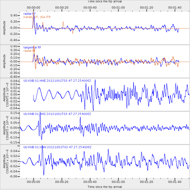
KNB Kanab, UT, USA - Earthquake Result Viewer
*The percent match for this event was below the threshold and hence no stack was calculated.
| Earthquake location: |
Sea Of Okhotsk |
| Earthquake latitude/longitude: |
53.2/152.8 |
| Earthquake time(UTC): |
2013/10/01 (274) 03:38:21 GMT |
| Earthquake Depth: |
573 km |
| Earthquake Magnitude: |
6.7 MWW, 6.7 MWC, 6.8 MWC, 6.8 MWB |
| Earthquake Catalog/Contributor: |
NEIC PDE/NEIC COMCAT |
|
| Network: |
UU University of Utah Regional Network |
| Station: |
KNB Kanab, UT, USA |
| Lat/Lon: |
37.02 N/112.82 W |
| Elevation: |
1715 m |
|
| Distance: |
63.8 deg |
| Az: |
62.831 deg |
| Baz: |
318.033 deg |
| Ray Param: |
$rayparam |
*The percent match for this event was below the threshold and hence was not used in the summary stack. |
|
| Radial Match: |
70.80003 % |
| Radial Bump: |
400 |
| Transverse Match: |
64.62649 % |
| Transverse Bump: |
400 |
| SOD ConfigId: |
626651 |
| Insert Time: |
2014-04-18 23:36:55.897 +0000 |
| GWidth: |
2.5 |
| Max Bumps: |
400 |
| Tol: |
0.001 |
|
Signal To Noise
| Channel | StoN | STA | LTA |
| UU:KNB:01:HHZ:20131001T03:47:27.254006Z | 2.3891134 | 5.0753613E-8 | 2.1243702E-8 |
| UU:KNB:01:HHN:20131001T03:47:27.254006Z | 1.3346288 | 1.0368888E-8 | 7.769118E-9 |
| UU:KNB:01:HHE:20131001T03:47:27.254006Z | 0.8643316 | 9.095811E-9 | 1.0523521E-8 |
| Arrivals |
| Ps | |
| PpPs | |
| PsPs/PpSs | |


