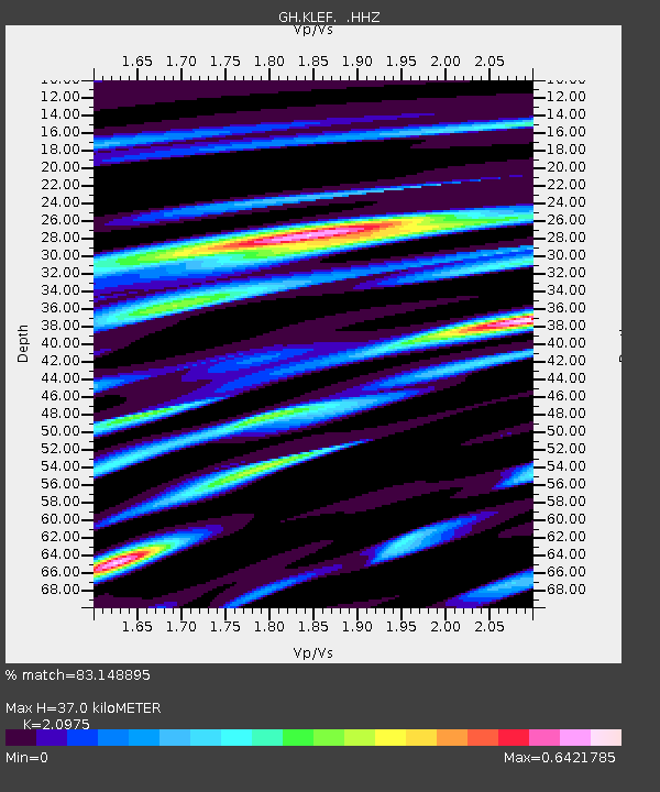
KLEF Ho, Ghana - Earthquake Result Viewer

Earthquake location: Owen Fracture Zone Region
Earthquake latitude/longitude: 11.2/57.6
Earthquake time(UTC): 2013/10/02 (275) 01:06:37 GMT
Earthquake Depth: 7.9 km
Earthquake Magnitude: 5.7 MWW, 5.6 MWB, 5.7 MWW, 5.8 MWC
Earthquake Catalog/Contributor: NEIC PDE/NEIC COMCAT
Network: GH Ghana Digital Seismic Network
Station: KLEF Ho, Ghana
Lat/Lon: 6.61 N/0.44 E
Elevation: 313 m
Distance: 56.6 deg
Az: 270.55 deg
Baz: 80.95 deg
Ray Param: 0.06405756
Estimated Moho Depth: 37.0 km
Estimated Crust Vp/Vs: 2.10
Assumed Crust Vp: 6.612 km/s
Estimated Crust Vs: 3.152 km/s
Estimated Crust Poisson's Ratio: 0.35
Radial Match: 83.148895 %
Radial Bump: 400
Transverse Match: 53.250835 %
Transverse Bump: 400
SOD ConfigId: 626651
Insert Time: 2014-04-18 23:44:24.598 +0000
GWidth: 2.5
Max Bumps: 400
Tol: 0.001

Signal To Noise

ChannelStoNSTALTA
GH:KLEF: :HHZ:20131002T01:15:49.31999Z2.9929483.3839393E-71.1306375E-7
GH:KLEF: :HHN:20131002T01:15:49.31999Z0.843873147.7908915E-89.232302E-8
GH:KLEF: :HHE:20131002T01:15:49.31999Z2.54816822.0272202E-77.955598E-8
Arrivals
Ps6.4 SECOND
PpPs17 SECOND
PsPs/PpSs23 SECOND