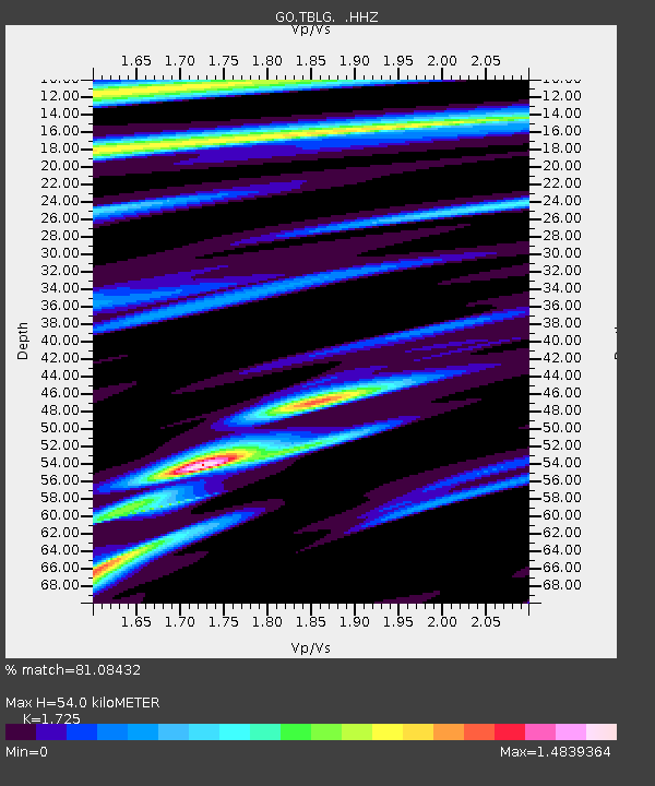
TBLG Delisi, Georgia - Earthquake Result Viewer

Earthquake location: Owen Fracture Zone Region
Earthquake latitude/longitude: 11.2/57.6
Earthquake time(UTC): 2013/10/02 (275) 01:06:37 GMT
Earthquake Depth: 7.9 km
Earthquake Magnitude: 5.7 MWW, 5.6 MWB, 5.7 MWW, 5.8 MWC
Earthquake Catalog/Contributor: NEIC PDE/NEIC COMCAT
Network: GO National Seismic Network of Georgia
Station: TBLG Delisi, Georgia
Lat/Lon: 41.73 N/44.74 E
Elevation: 510 m
Distance: 32.4 deg
Az: 341.902 deg
Baz: 155.972 deg
Ray Param: 0.07866828
Estimated Moho Depth: 54.0 km
Estimated Crust Vp/Vs: 1.73
Assumed Crust Vp: 6.291 km/s
Estimated Crust Vs: 3.647 km/s
Estimated Crust Poisson's Ratio: 0.25
Radial Match: 81.08432 %
Radial Bump: 400
Transverse Match: 60.82496 %
Transverse Bump: 400
SOD ConfigId: 626651
Insert Time: 2014-04-18 23:44:46.031 +0000
GWidth: 2.5
Max Bumps: 400
Tol: 0.001

Signal To Noise

ChannelStoNSTALTA
GO:TBLG: :HHZ:20131002T01:12:36.859999Z5.0348822.7671223E-75.4959028E-8
GO:TBLG: :HHN:20131002T01:12:36.859999Z2.40765981.4282335E-75.9320403E-8
GO:TBLG: :HHE:20131002T01:12:36.859999Z0.88955475.7682445E-86.484418E-8
Arrivals
Ps6.7 SECOND
PpPs22 SECOND
PsPs/PpSs28 SECOND