You are here: Home > Network List > II - Global Seismograph Network (GSN - IRIS/IDA) Stations List
> Station ABKT Alibek, Turkmenistan > Earthquake Result Viewer
ABKT Alibek, Turkmenistan - Earthquake Result Viewer
| Earthquake location: |
Mid-Indian Ridge |
| Earthquake latitude/longitude: |
-38.6/78.4 |
| Earthquake time(UTC): |
2013/10/04 (277) 17:26:13 GMT |
| Earthquake Depth: |
13 km |
| Earthquake Magnitude: |
6.4 MWW, 6.3 MWB, 6.4 MWC, 6.4 MWW |
| Earthquake Catalog/Contributor: |
NEIC PDE/NEIC COMCAT |
|
| Network: |
II Global Seismograph Network (GSN - IRIS/IDA) |
| Station: |
ABKT Alibek, Turkmenistan |
| Lat/Lon: |
37.93 N/58.12 E |
| Elevation: |
678 m |
|
| Distance: |
78.4 deg |
| Az: |
343.776 deg |
| Baz: |
163.929 deg |
| Ray Param: |
0.049654182 |
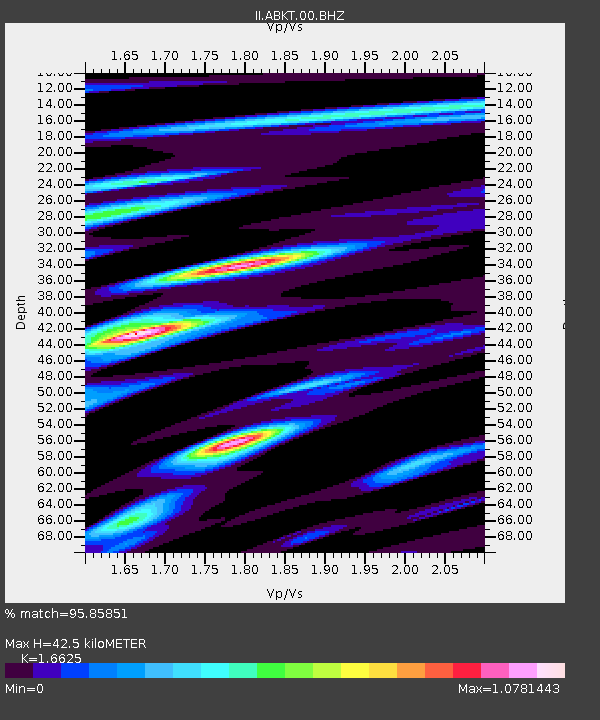
| Estimated Moho Depth: |
42.5 km |
| Estimated Crust Vp/Vs: |
1.66 |
| Assumed Crust Vp: |
6.53 km/s |
| Estimated Crust Vs: |
3.928 km/s |
| Estimated Crust Poisson's Ratio: |
0.22 |
|
| Radial Match: |
95.85851 % |
| Radial Bump: |
400 |
| Transverse Match: |
94.2674 % |
| Transverse Bump: |
400 |
| SOD ConfigId: |
626651 |
| Insert Time: |
2014-04-18 23:53:29.841 +0000 |
| GWidth: |
2.5 |
| Max Bumps: |
400 |
| Tol: |
0.001 |
|

Signal To Noise
| Channel | StoN | STA | LTA |
| II:ABKT:00:BHZ:20131004T17:37:42.568975Z | 3.9004567 | 1.9690837E-7 | 5.0483415E-8 |
| II:ABKT:00:BHN:20131004T17:37:42.568975Z | 2.5618632 | 7.9476806E-8 | 3.102305E-8 |
| II:ABKT:00:BHE:20131004T17:37:42.568975Z | 1.6949701 | 8.3554454E-8 | 4.9295533E-8 |
| Arrivals |
| Ps | 4.5 SECOND |
| PpPs | 17 SECOND |
| PsPs/PpSs | 21 SECOND |


