You are here: Home > Network List > II - Global Seismograph Network (GSN - IRIS/IDA) Stations List
> Station NIL Nilore, Pakistan > Earthquake Result Viewer
NIL Nilore, Pakistan - Earthquake Result Viewer
| Earthquake location: |
Mid-Indian Ridge |
| Earthquake latitude/longitude: |
-38.6/78.4 |
| Earthquake time(UTC): |
2013/10/04 (277) 17:26:13 GMT |
| Earthquake Depth: |
13 km |
| Earthquake Magnitude: |
6.4 MWW, 6.3 MWB, 6.4 MWC, 6.4 MWW |
| Earthquake Catalog/Contributor: |
NEIC PDE/NEIC COMCAT |
|
| Network: |
II Global Seismograph Network (GSN - IRIS/IDA) |
| Station: |
NIL Nilore, Pakistan |
| Lat/Lon: |
33.65 N/73.27 E |
| Elevation: |
629 m |
|
| Distance: |
72.0 deg |
| Az: |
355.529 deg |
| Baz: |
175.801 deg |
| Ray Param: |
0.05391523 |
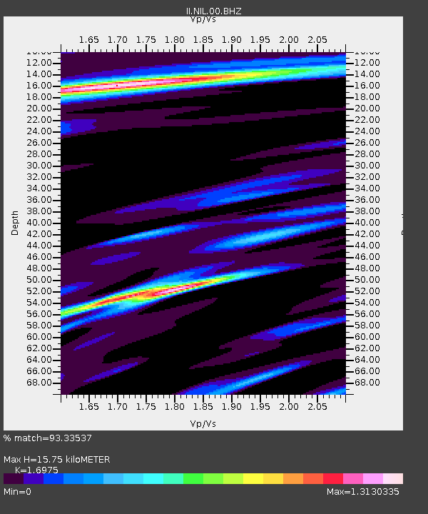
| Estimated Moho Depth: |
15.75 km |
| Estimated Crust Vp/Vs: |
1.70 |
| Assumed Crust Vp: |
6.242 km/s |
| Estimated Crust Vs: |
3.677 km/s |
| Estimated Crust Poisson's Ratio: |
0.23 |
|
| Radial Match: |
93.33537 % |
| Radial Bump: |
356 |
| Transverse Match: |
78.76052 % |
| Transverse Bump: |
400 |
| SOD ConfigId: |
626651 |
| Insert Time: |
2014-04-18 23:53:46.450 +0000 |
| GWidth: |
2.5 |
| Max Bumps: |
400 |
| Tol: |
0.001 |
|

Signal To Noise
| Channel | StoN | STA | LTA |
| II:NIL:00:BHZ:20131004T17:37:06.018987Z | 4.0028 | 2.7017725E-7 | 6.749706E-8 |
| II:NIL:00:BH1:20131004T17:37:06.018987Z | 0.9254161 | 6.8466825E-8 | 7.398491E-8 |
| II:NIL:00:BH2:20131004T17:37:06.018987Z | 0.67403036 | 4.38525E-8 | 6.506012E-8 |
| Arrivals |
| Ps | 1.8 SECOND |
| PpPs | 6.6 SECOND |
| PsPs/PpSs | 8.4 SECOND |


