You are here: Home > Network List > AV - Alaska Volcano Observatory Stations List
> Station AUJA Augustine Cone H, Augustine Volcano, Alaska > Earthquake Result Viewer
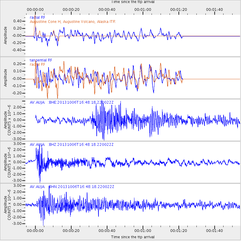
AUJA Augustine Cone H, Augustine Volcano, Alaska - Earthquake Result Viewer
*The percent match for this event was below the threshold and hence no stack was calculated.
| Earthquake location: |
South Of Mariana Islands |
| Earthquake latitude/longitude: |
12.3/141.7 |
| Earthquake time(UTC): |
2013/10/06 (279) 16:38:08 GMT |
| Earthquake Depth: |
104 km |
| Earthquake Magnitude: |
6.0 MWW, 6.0 MWB, 6.0 MWW, 6.1 MWC |
| Earthquake Catalog/Contributor: |
NEIC PDE/NEIC COMCAT |
|
| Network: |
AV Alaska Volcano Observatory |
| Station: |
AUJA Augustine Cone H, Augustine Volcano, Alaska |
| Lat/Lon: |
59.34 N/153.42 W |
| Elevation: |
376 m |
|
| Distance: |
66.8 deg |
| Az: |
30.331 deg |
| Baz: |
254.369 deg |
| Ray Param: |
$rayparam |
*The percent match for this event was below the threshold and hence was not used in the summary stack. |
|
| Radial Match: |
52.429165 % |
| Radial Bump: |
400 |
| Transverse Match: |
53.14722 % |
| Transverse Bump: |
400 |
| SOD ConfigId: |
626651 |
| Insert Time: |
2014-04-19 00:03:25.291 +0000 |
| GWidth: |
2.5 |
| Max Bumps: |
400 |
| Tol: |
0.001 |
|
Signal To Noise
| Channel | StoN | STA | LTA |
| AV:AUJA: :BHZ:20131006T16:48:18.220022Z | 7.3046784 | 1.2941765E-6 | 1.7717092E-7 |
| AV:AUJA: :BHN:20131006T16:48:18.220022Z | 4.276766 | 9.429299E-7 | 2.2047733E-7 |
| AV:AUJA: :BHE:20131006T16:48:18.220022Z | 2.710092 | 7.5810476E-7 | 2.7973397E-7 |
| Arrivals |
| Ps | |
| PpPs | |
| PsPs/PpSs | |


