You are here: Home > Network List > CN - Canadian National Seismograph Network Stations List
> Station INK INUVIK, NT > Earthquake Result Viewer
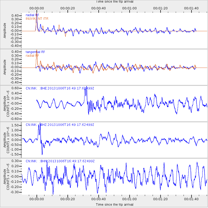
INK INUVIK, NT - Earthquake Result Viewer
*The percent match for this event was below the threshold and hence no stack was calculated.
| Earthquake location: |
South Of Mariana Islands |
| Earthquake latitude/longitude: |
12.3/141.7 |
| Earthquake time(UTC): |
2013/10/06 (279) 16:38:08 GMT |
| Earthquake Depth: |
104 km |
| Earthquake Magnitude: |
6.0 MWW, 6.0 MWB, 6.0 MWW, 6.1 MWC |
| Earthquake Catalog/Contributor: |
NEIC PDE/NEIC COMCAT |
|
| Network: |
CN Canadian National Seismograph Network |
| Station: |
INK INUVIK, NT |
| Lat/Lon: |
68.31 N/133.53 W |
| Elevation: |
44 m |
|
| Distance: |
76.7 deg |
| Az: |
22.36 deg |
| Baz: |
269.782 deg |
| Ray Param: |
$rayparam |
*The percent match for this event was below the threshold and hence was not used in the summary stack. |
|
| Radial Match: |
73.51362 % |
| Radial Bump: |
400 |
| Transverse Match: |
58.872913 % |
| Transverse Bump: |
400 |
| SOD ConfigId: |
626651 |
| Insert Time: |
2014-04-19 00:07:52.055 +0000 |
| GWidth: |
2.5 |
| Max Bumps: |
400 |
| Tol: |
0.001 |
|
Signal To Noise
| Channel | StoN | STA | LTA |
| CN:INK: :BHZ:20131006T16:49:17.62499Z | 6.671213 | 8.1588104E-7 | 1.2229876E-7 |
| CN:INK: :BHN:20131006T16:49:17.62499Z | 0.79157466 | 7.350858E-8 | 9.2863736E-8 |
| CN:INK: :BHE:20131006T16:49:17.62499Z | 3.1124177 | 3.0062307E-7 | 9.658828E-8 |
| Arrivals |
| Ps | |
| PpPs | |
| PsPs/PpSs | |


