You are here: Home > Network List > IW - Intermountain West Stations List
> Station DLMT Dillon, Montana, USA > Earthquake Result Viewer
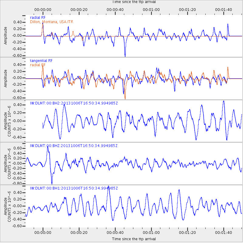
DLMT Dillon, Montana, USA - Earthquake Result Viewer
*The percent match for this event was below the threshold and hence no stack was calculated.
| Earthquake location: |
South Of Mariana Islands |
| Earthquake latitude/longitude: |
12.3/141.7 |
| Earthquake time(UTC): |
2013/10/06 (279) 16:38:08 GMT |
| Earthquake Depth: |
104 km |
| Earthquake Magnitude: |
6.0 MWW, 6.0 MWB, 6.0 MWW, 6.1 MWC |
| Earthquake Catalog/Contributor: |
NEIC PDE/NEIC COMCAT |
|
| Network: |
IW Intermountain West |
| Station: |
DLMT Dillon, Montana, USA |
| Lat/Lon: |
45.36 N/112.60 W |
| Elevation: |
1569 m |
|
| Distance: |
92.1 deg |
| Az: |
42.774 deg |
| Baz: |
289.712 deg |
| Ray Param: |
$rayparam |
*The percent match for this event was below the threshold and hence was not used in the summary stack. |
|
| Radial Match: |
56.347538 % |
| Radial Bump: |
400 |
| Transverse Match: |
52.789593 % |
| Transverse Bump: |
355 |
| SOD ConfigId: |
626651 |
| Insert Time: |
2014-04-19 00:12:01.028 +0000 |
| GWidth: |
2.5 |
| Max Bumps: |
400 |
| Tol: |
0.001 |
|
Signal To Noise
| Channel | StoN | STA | LTA |
| IW:DLMT:00:BHZ:20131006T16:50:34.994985Z | 2.6442587 | 3.339154E-7 | 1.262794E-7 |
| IW:DLMT:00:BH1:20131006T16:50:34.994985Z | 0.5484531 | 9.421467E-8 | 1.7178256E-7 |
| IW:DLMT:00:BH2:20131006T16:50:34.994985Z | 0.7792339 | 1.4047917E-7 | 1.8027858E-7 |
| Arrivals |
| Ps | |
| PpPs | |
| PsPs/PpSs | |


