You are here: Home > Network List > IW - Intermountain West Stations List
> Station PLID Pearl Lake, Idaho, USA > Earthquake Result Viewer
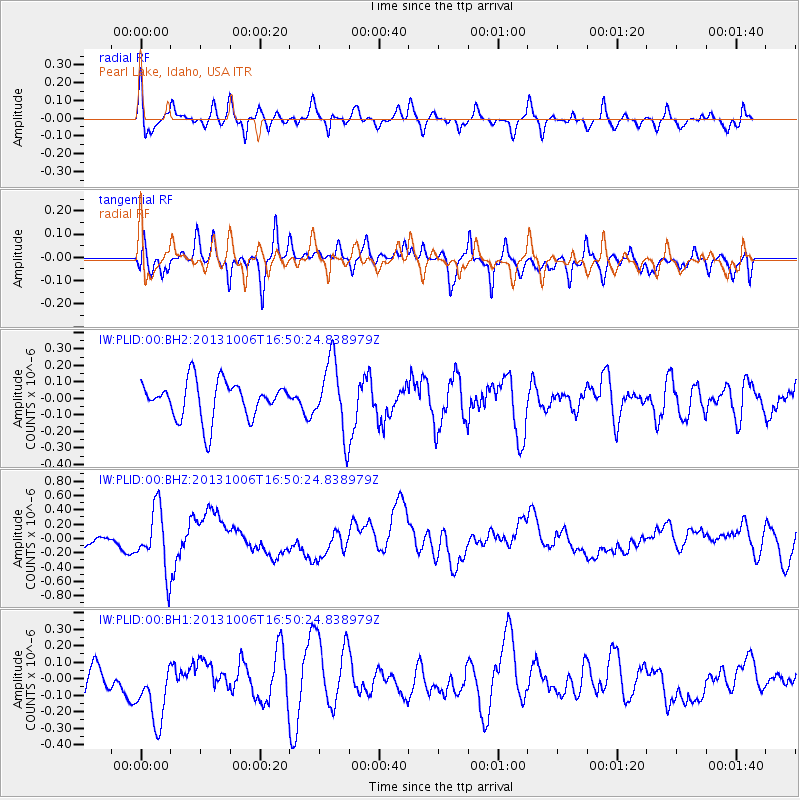
PLID Pearl Lake, Idaho, USA - Earthquake Result Viewer
*The percent match for this event was below the threshold and hence no stack was calculated.
| Earthquake location: |
South Of Mariana Islands |
| Earthquake latitude/longitude: |
12.3/141.7 |
| Earthquake time(UTC): |
2013/10/06 (279) 16:38:08 GMT |
| Earthquake Depth: |
104 km |
| Earthquake Magnitude: |
6.0 MWW, 6.0 MWB, 6.0 MWW, 6.1 MWC |
| Earthquake Catalog/Contributor: |
NEIC PDE/NEIC COMCAT |
|
| Network: |
IW Intermountain West |
| Station: |
PLID Pearl Lake, Idaho, USA |
| Lat/Lon: |
45.09 N/116.00 W |
| Elevation: |
2164 m |
|
| Distance: |
89.9 deg |
| Az: |
43.798 deg |
| Baz: |
287.286 deg |
| Ray Param: |
$rayparam |
*The percent match for this event was below the threshold and hence was not used in the summary stack. |
|
| Radial Match: |
59.46551 % |
| Radial Bump: |
354 |
| Transverse Match: |
51.678143 % |
| Transverse Bump: |
400 |
| SOD ConfigId: |
626651 |
| Insert Time: |
2014-04-19 00:12:15.944 +0000 |
| GWidth: |
2.5 |
| Max Bumps: |
400 |
| Tol: |
0.001 |
|
Signal To Noise
| Channel | StoN | STA | LTA |
| IW:PLID:00:BHZ:20131006T16:50:24.838979Z | 4.6170273 | 4.3216357E-7 | 9.3602125E-8 |
| IW:PLID:00:BH1:20131006T16:50:24.838979Z | 2.2081459 | 2.1243592E-7 | 9.6205575E-8 |
| IW:PLID:00:BH2:20131006T16:50:24.838979Z | 1.9064871 | 2.1510925E-7 | 1.12830165E-7 |
| Arrivals |
| Ps | |
| PpPs | |
| PsPs/PpSs | |


