You are here: Home > Network List > AV - Alaska Volcano Observatory Stations List
> Station MAPS Pakushin Southeast, Makushin Volcano, Alaska > Earthquake Result Viewer
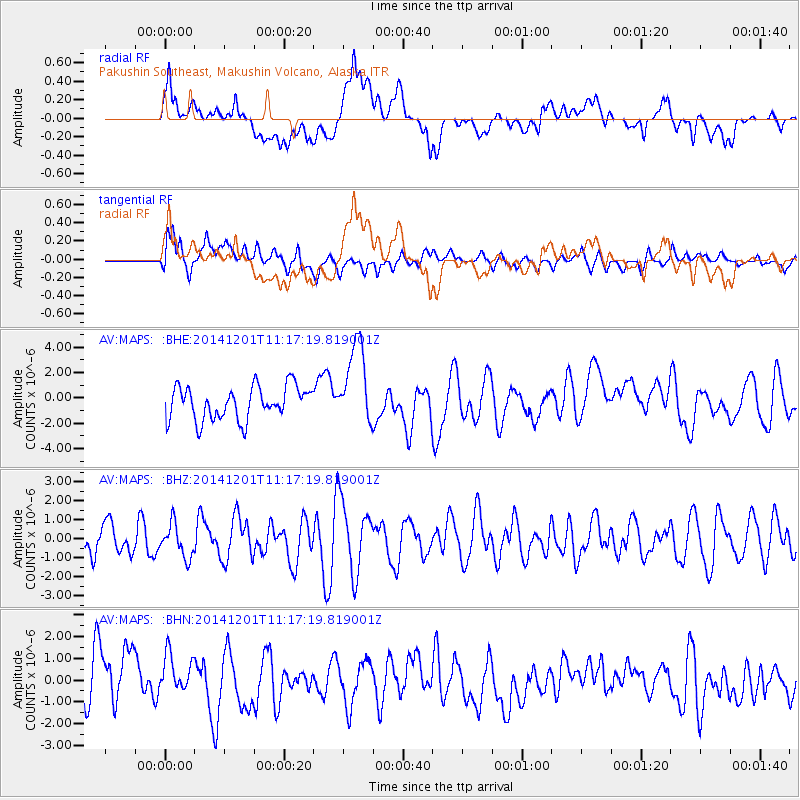
MAPS Pakushin Southeast, Makushin Volcano, Alaska - Earthquake Result Viewer
*The percent match for this event was below the threshold and hence no stack was calculated.
| Earthquake location: |
Mindanao, Philippines |
| Earthquake latitude/longitude: |
5.4/126.7 |
| Earthquake time(UTC): |
2014/12/01 (335) 11:06:35 GMT |
| Earthquake Depth: |
65 km |
| Earthquake Magnitude: |
5.1 MW |
| Earthquake Catalog/Contributor: |
ISC/ISC |
|
| Network: |
AV Alaska Volcano Observatory |
| Station: |
MAPS Pakushin Southeast, Makushin Volcano, Alaska |
| Lat/Lon: |
53.81 N/166.94 W |
| Elevation: |
333 m |
|
| Distance: |
71.8 deg |
| Az: |
34.886 deg |
| Baz: |
253.762 deg |
| Ray Param: |
$rayparam |
*The percent match for this event was below the threshold and hence was not used in the summary stack. |
|
| Radial Match: |
43.96065 % |
| Radial Bump: |
400 |
| Transverse Match: |
57.01371 % |
| Transverse Bump: |
400 |
| SOD ConfigId: |
3390531 |
| Insert Time: |
2019-04-15 06:35:59.872 +0000 |
| GWidth: |
2.5 |
| Max Bumps: |
400 |
| Tol: |
0.001 |
|
Signal To Noise
| Channel | StoN | STA | LTA |
| AV:MAPS: :BHZ:20141201T11:17:19.819001Z | 1.1637946 | 8.785893E-7 | 7.54935E-7 |
| AV:MAPS: :BHN:20141201T11:17:19.819001Z | 0.68387353 | 9.131889E-7 | 1.3353183E-6 |
| AV:MAPS: :BHE:20141201T11:17:19.819001Z | 2.4988377 | 3.2662076E-6 | 1.3070907E-6 |
| Arrivals |
| Ps | |
| PpPs | |
| PsPs/PpSs | |


