You are here: Home > Network List > TJ - Tajikistan National Seismic Network Stations List
> Station GARM Garm, Tajikistan > Earthquake Result Viewer
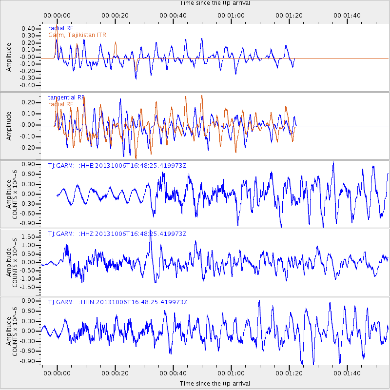
GARM Garm, Tajikistan - Earthquake Result Viewer
*The percent match for this event was below the threshold and hence no stack was calculated.
| Earthquake location: |
South Of Mariana Islands |
| Earthquake latitude/longitude: |
12.3/141.7 |
| Earthquake time(UTC): |
2013/10/06 (279) 16:38:08 GMT |
| Earthquake Depth: |
104 km |
| Earthquake Magnitude: |
6.0 MWW, 6.0 MWB, 6.0 MWW, 6.1 MWC |
| Earthquake Catalog/Contributor: |
NEIC PDE/NEIC COMCAT |
|
| Network: |
TJ Tajikistan National Seismic Network |
| Station: |
GARM Garm, Tajikistan |
| Lat/Lon: |
39.00 N/70.32 E |
| Elevation: |
1305 m |
|
| Distance: |
67.9 deg |
| Az: |
307.167 deg |
| Baz: |
91.889 deg |
| Ray Param: |
$rayparam |
*The percent match for this event was below the threshold and hence was not used in the summary stack. |
|
| Radial Match: |
71.59803 % |
| Radial Bump: |
400 |
| Transverse Match: |
72.374466 % |
| Transverse Bump: |
400 |
| SOD ConfigId: |
626651 |
| Insert Time: |
2014-04-19 00:18:51.430 +0000 |
| GWidth: |
2.5 |
| Max Bumps: |
400 |
| Tol: |
0.001 |
|
Signal To Noise
| Channel | StoN | STA | LTA |
| TJ:GARM: :HHZ:20131006T16:48:25.419973Z | 3.0258753 | 4.399199E-7 | 1.4538598E-7 |
| TJ:GARM: :HHN:20131006T16:48:25.419973Z | 1.9839483 | 1.7710171E-7 | 8.9267296E-8 |
| TJ:GARM: :HHE:20131006T16:48:25.419973Z | 2.0841565 | 3.079116E-7 | 1.477392E-7 |
| Arrivals |
| Ps | |
| PpPs | |
| PsPs/PpSs | |


