You are here: Home > Network List > US - United States National Seismic Network Stations List
> Station EGMT Eagleton, Montana, USA > Earthquake Result Viewer
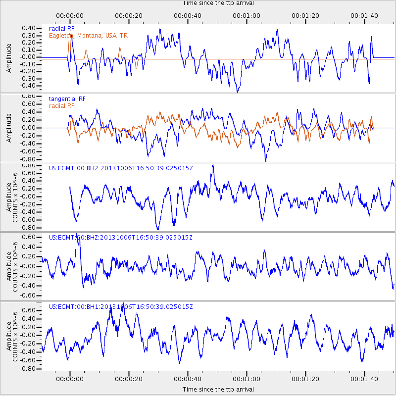
EGMT Eagleton, Montana, USA - Earthquake Result Viewer
*The percent match for this event was below the threshold and hence no stack was calculated.
| Earthquake location: |
South Of Mariana Islands |
| Earthquake latitude/longitude: |
12.3/141.7 |
| Earthquake time(UTC): |
2013/10/06 (279) 16:38:08 GMT |
| Earthquake Depth: |
104 km |
| Earthquake Magnitude: |
6.0 MWW, 6.0 MWB, 6.0 MWW, 6.1 MWC |
| Earthquake Catalog/Contributor: |
NEIC PDE/NEIC COMCAT |
|
| Network: |
US United States National Seismic Network |
| Station: |
EGMT Eagleton, Montana, USA |
| Lat/Lon: |
48.02 N/109.75 W |
| Elevation: |
1055 m |
|
| Distance: |
93.0 deg |
| Az: |
39.588 deg |
| Baz: |
291.915 deg |
| Ray Param: |
$rayparam |
*The percent match for this event was below the threshold and hence was not used in the summary stack. |
|
| Radial Match: |
51.316093 % |
| Radial Bump: |
400 |
| Transverse Match: |
52.2535 % |
| Transverse Bump: |
400 |
| SOD ConfigId: |
626651 |
| Insert Time: |
2014-04-19 00:19:34.339 +0000 |
| GWidth: |
2.5 |
| Max Bumps: |
400 |
| Tol: |
0.001 |
|
Signal To Noise
| Channel | StoN | STA | LTA |
| US:EGMT:00:BHZ:20131006T16:50:39.025015Z | 2.5902882 | 3.3259286E-7 | 1.2839995E-7 |
| US:EGMT:00:BH1:20131006T16:50:39.025015Z | 1.555837 | 3.814924E-7 | 2.4520077E-7 |
| US:EGMT:00:BH2:20131006T16:50:39.025015Z | 2.0845268 | 4.453159E-7 | 2.1362925E-7 |
| Arrivals |
| Ps | |
| PpPs | |
| PsPs/PpSs | |


