You are here: Home > Network List > US - United States National Seismic Network Stations List
> Station WUAZ Wupatki, Arizona, USA > Earthquake Result Viewer
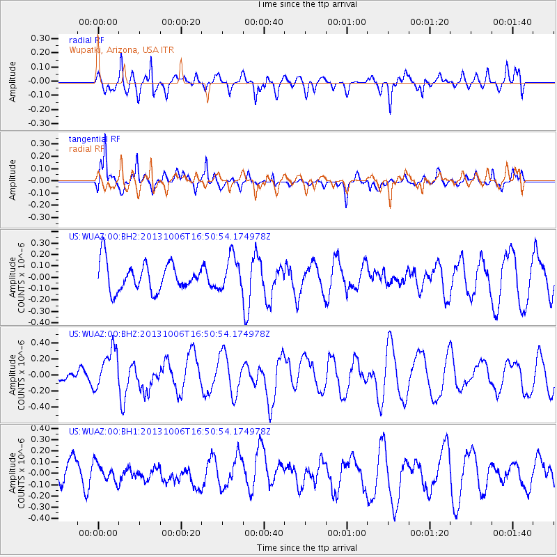
WUAZ Wupatki, Arizona, USA - Earthquake Result Viewer
*The percent match for this event was below the threshold and hence no stack was calculated.
| Earthquake location: |
South Of Mariana Islands |
| Earthquake latitude/longitude: |
12.3/141.7 |
| Earthquake time(UTC): |
2013/10/06 (279) 16:38:08 GMT |
| Earthquake Depth: |
104 km |
| Earthquake Magnitude: |
6.0 MWW, 6.0 MWB, 6.0 MWW, 6.1 MWC |
| Earthquake Catalog/Contributor: |
NEIC PDE/NEIC COMCAT |
|
| Network: |
US United States National Seismic Network |
| Station: |
WUAZ Wupatki, Arizona, USA |
| Lat/Lon: |
35.52 N/111.37 W |
| Elevation: |
1592 m |
|
| Distance: |
96.3 deg |
| Az: |
51.734 deg |
| Baz: |
289.848 deg |
| Ray Param: |
$rayparam |
*The percent match for this event was below the threshold and hence was not used in the summary stack. |
|
| Radial Match: |
66.5575 % |
| Radial Bump: |
400 |
| Transverse Match: |
63.50162 % |
| Transverse Bump: |
381 |
| SOD ConfigId: |
626651 |
| Insert Time: |
2014-04-19 00:20:08.096 +0000 |
| GWidth: |
2.5 |
| Max Bumps: |
400 |
| Tol: |
0.001 |
|
Signal To Noise
| Channel | StoN | STA | LTA |
| US:WUAZ:00:BHZ:20131006T16:50:54.174978Z | 1.8777947 | 2.5117183E-7 | 1.3375893E-7 |
| US:WUAZ:00:BH1:20131006T16:50:54.174978Z | 0.68695444 | 8.106762E-8 | 1.18010185E-7 |
| US:WUAZ:00:BH2:20131006T16:50:54.174978Z | 1.219487 | 1.5035728E-7 | 1.2329552E-7 |
| Arrivals |
| Ps | |
| PpPs | |
| PsPs/PpSs | |


