You are here: Home > Network List > UW - Pacific Northwest Regional Seismic Network Stations List
> Station LEBA Lebam, WA, USA > Earthquake Result Viewer
LEBA Lebam, WA, USA - Earthquake Result Viewer
*The percent match for this event was below the threshold and hence no stack was calculated.
| Earthquake location: |
South Of Mariana Islands |
| Earthquake latitude/longitude: |
12.3/141.7 |
| Earthquake time(UTC): |
2013/10/06 (279) 16:38:08 GMT |
| Earthquake Depth: |
104 km |
| Earthquake Magnitude: |
6.0 MWW, 6.0 MWB, 6.0 MWW, 6.1 MWC |
| Earthquake Catalog/Contributor: |
NEIC PDE/NEIC COMCAT |
|
| Network: |
UW Pacific Northwest Regional Seismic Network |
| Station: |
LEBA Lebam, WA, USA |
| Lat/Lon: |
46.55 N/123.56 W |
| Elevation: |
73 m |
|
| Distance: |
84.4 deg |
| Az: |
43.72 deg |
| Baz: |
281.872 deg |
| Ray Param: |
$rayparam |
*The percent match for this event was below the threshold and hence was not used in the summary stack. |
|
| Radial Match: |
58.31903 % |
| Radial Bump: |
400 |
| Transverse Match: |
64.133385 % |
| Transverse Bump: |
400 |
| SOD ConfigId: |
626651 |
| Insert Time: |
2014-04-19 00:21:50.855 +0000 |
| GWidth: |
2.5 |
| Max Bumps: |
400 |
| Tol: |
0.001 |
|
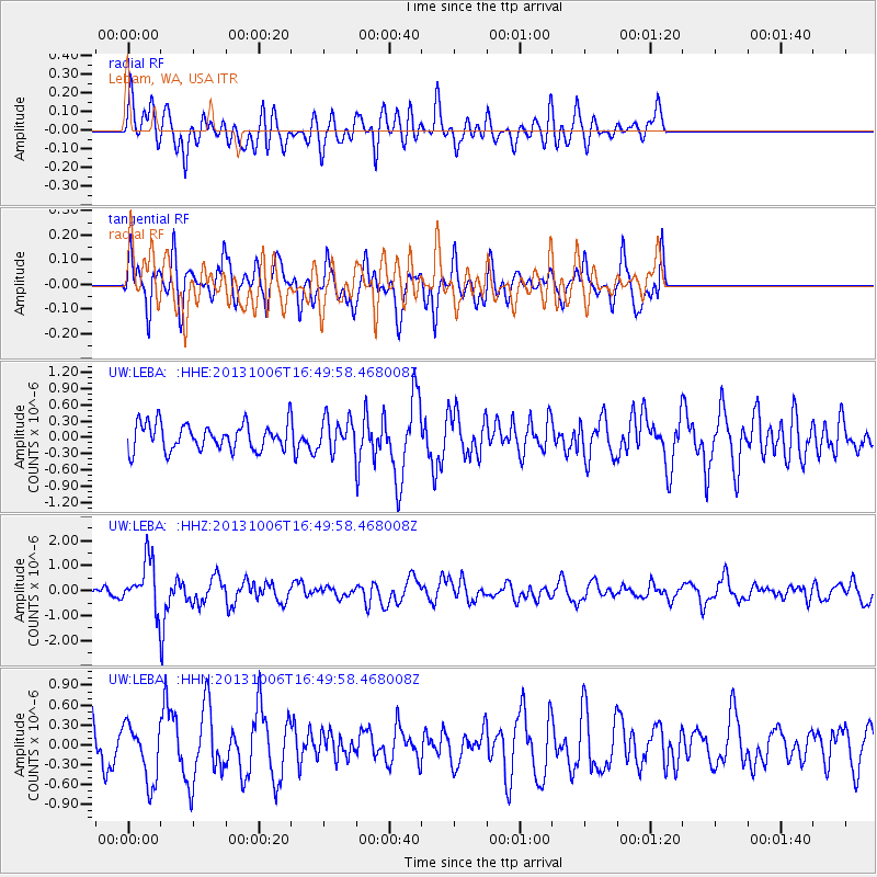
Signal To Noise
| Channel | StoN | STA | LTA |
| UW:LEBA: :HHZ:20131006T16:49:58.468008Z | 3.232717 | 9.753752E-7 | 3.0171992E-7 |
| UW:LEBA: :HHN:20131006T16:49:58.468008Z | 1.6263771 | 4.319924E-7 | 2.6561636E-7 |
| UW:LEBA: :HHE:20131006T16:49:58.468008Z | 1.2024432 | 2.9083822E-7 | 2.4187273E-7 |
| Arrivals |
| Ps | |
| PpPs | |
| PsPs/PpSs | |


