You are here: Home > Network List > WY - Yellowstone Wyoming Seismic Network Stations List
> Station YHH Holmes Hill, YNP, WY, USA > Earthquake Result Viewer
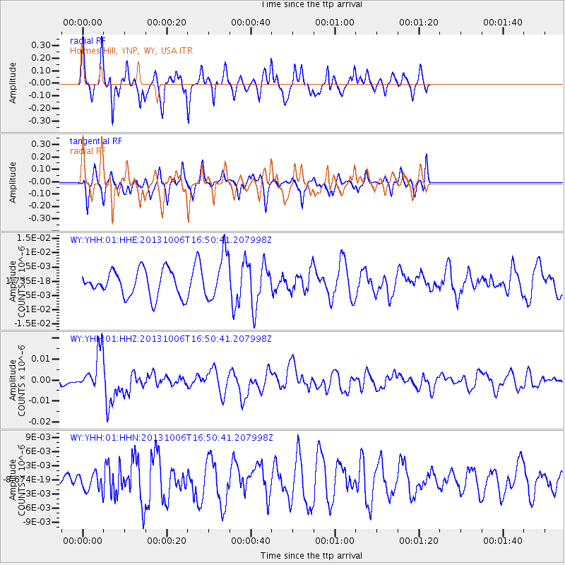
YHH Holmes Hill, YNP, WY, USA - Earthquake Result Viewer
*The percent match for this event was below the threshold and hence no stack was calculated.
| Earthquake location: |
South Of Mariana Islands |
| Earthquake latitude/longitude: |
12.3/141.7 |
| Earthquake time(UTC): |
2013/10/06 (279) 16:38:08 GMT |
| Earthquake Depth: |
104 km |
| Earthquake Magnitude: |
6.0 MWW, 6.0 MWB, 6.0 MWW, 6.1 MWC |
| Earthquake Catalog/Contributor: |
NEIC PDE/NEIC COMCAT |
|
| Network: |
WY Yellowstone Wyoming Seismic Network |
| Station: |
YHH Holmes Hill, YNP, WY, USA |
| Lat/Lon: |
44.79 N/110.85 W |
| Elevation: |
2717 m |
|
| Distance: |
93.4 deg |
| Az: |
42.883 deg |
| Baz: |
290.939 deg |
| Ray Param: |
$rayparam |
*The percent match for this event was below the threshold and hence was not used in the summary stack. |
|
| Radial Match: |
65.79305 % |
| Radial Bump: |
346 |
| Transverse Match: |
43.87136 % |
| Transverse Bump: |
363 |
| SOD ConfigId: |
626651 |
| Insert Time: |
2014-04-19 00:22:48.703 +0000 |
| GWidth: |
2.5 |
| Max Bumps: |
400 |
| Tol: |
0.001 |
|
Signal To Noise
| Channel | StoN | STA | LTA |
| WY:YHH:01:HHZ:20131006T16:50:41.207998Z | 2.819539 | 9.695587E-9 | 3.4387133E-9 |
| WY:YHH:01:HHN:20131006T16:50:41.207998Z | 0.6733894 | 1.7898384E-9 | 2.6579547E-9 |
| WY:YHH:01:HHE:20131006T16:50:41.207998Z | 1.7945797 | 8.068644E-9 | 4.4961195E-9 |
| Arrivals |
| Ps | |
| PpPs | |
| PsPs/PpSs | |


