You are here: Home > Network List > TA - USArray Transportable Network (new EarthScope stations) Stations List
> Station W60A Pink Hill, NC, USA > Earthquake Result Viewer
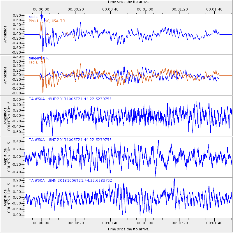
W60A Pink Hill, NC, USA - Earthquake Result Viewer
*The percent match for this event was below the threshold and hence no stack was calculated.
| Earthquake location: |
West Chile Rise |
| Earthquake latitude/longitude: |
-36.7/-97.5 |
| Earthquake time(UTC): |
2013/10/06 (279) 21:33:19 GMT |
| Earthquake Depth: |
10 km |
| Earthquake Magnitude: |
6.2 MWW, 5.9 MWB, 6.2 MWC, 6.3 MWC |
| Earthquake Catalog/Contributor: |
NEIC PDE/NEIC COMCAT |
|
| Network: |
TA USArray Transportable Network (new EarthScope stations) |
| Station: |
W60A Pink Hill, NC, USA |
| Lat/Lon: |
35.05 N/77.71 W |
| Elevation: |
30 m |
|
| Distance: |
73.7 deg |
| Az: |
16.796 deg |
| Baz: |
196.437 deg |
| Ray Param: |
$rayparam |
*The percent match for this event was below the threshold and hence was not used in the summary stack. |
|
| Radial Match: |
60.084896 % |
| Radial Bump: |
400 |
| Transverse Match: |
49.848248 % |
| Transverse Bump: |
400 |
| SOD ConfigId: |
626651 |
| Insert Time: |
2014-04-19 00:45:42.985 +0000 |
| GWidth: |
2.5 |
| Max Bumps: |
400 |
| Tol: |
0.001 |
|
Signal To Noise
| Channel | StoN | STA | LTA |
| TA:W60A: :BHZ:20131006T21:44:22.623975Z | 1.2848884 | 1.1917097E-7 | 9.274812E-8 |
| TA:W60A: :BHN:20131006T21:44:22.623975Z | 1.1126349 | 2.414334E-7 | 2.1699249E-7 |
| TA:W60A: :BHE:20131006T21:44:22.623975Z | 1.1250907 | 2.0207331E-7 | 1.7960623E-7 |
| Arrivals |
| Ps | |
| PpPs | |
| PsPs/PpSs | |


