You are here: Home > Network List > TA - USArray Transportable Network (new EarthScope stations) Stations List
> Station Y57A Sumter, SC, USA > Earthquake Result Viewer
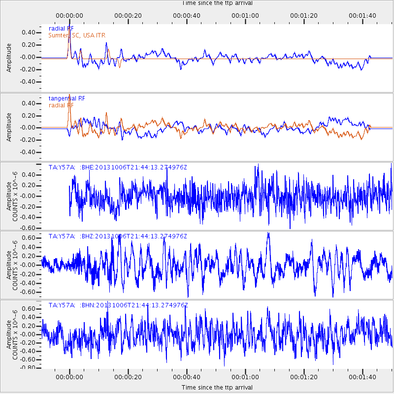
Y57A Sumter, SC, USA - Earthquake Result Viewer
*The percent match for this event was below the threshold and hence no stack was calculated.
| Earthquake location: |
West Chile Rise |
| Earthquake latitude/longitude: |
-36.7/-97.5 |
| Earthquake time(UTC): |
2013/10/06 (279) 21:33:19 GMT |
| Earthquake Depth: |
10 km |
| Earthquake Magnitude: |
6.2 MWW, 5.9 MWB, 6.2 MWC, 6.3 MWC |
| Earthquake Catalog/Contributor: |
NEIC PDE/NEIC COMCAT |
|
| Network: |
TA USArray Transportable Network (new EarthScope stations) |
| Station: |
Y57A Sumter, SC, USA |
| Lat/Lon: |
34.02 N/80.39 W |
| Elevation: |
56 m |
|
| Distance: |
72.2 deg |
| Az: |
14.853 deg |
| Baz: |
194.356 deg |
| Ray Param: |
$rayparam |
*The percent match for this event was below the threshold and hence was not used in the summary stack. |
|
| Radial Match: |
61.675453 % |
| Radial Bump: |
400 |
| Transverse Match: |
44.77213 % |
| Transverse Bump: |
400 |
| SOD ConfigId: |
626651 |
| Insert Time: |
2014-04-19 00:46:12.853 +0000 |
| GWidth: |
2.5 |
| Max Bumps: |
400 |
| Tol: |
0.001 |
|
Signal To Noise
| Channel | StoN | STA | LTA |
| TA:Y57A: :BHZ:20131006T21:44:13.274976Z | 1.2859324 | 1.2204706E-7 | 9.490938E-8 |
| TA:Y57A: :BHN:20131006T21:44:13.274976Z | 1.8067306 | 2.903377E-7 | 1.6069784E-7 |
| TA:Y57A: :BHE:20131006T21:44:13.274976Z | 1.0628262 | 1.906883E-7 | 1.7941626E-7 |
| Arrivals |
| Ps | |
| PpPs | |
| PsPs/PpSs | |


