You are here: Home > Network List > IU - Global Seismograph Network (GSN - IRIS/USGS) Stations List
> Station CTAO Charters Towers, Australia > Earthquake Result Viewer
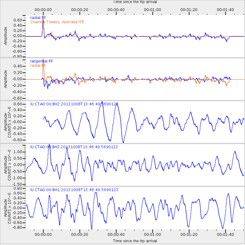
CTAO Charters Towers, Australia - Earthquake Result Viewer
*The percent match for this event was below the threshold and hence no stack was calculated.
| Earthquake location: |
West Of Macquarie Island |
| Earthquake latitude/longitude: |
-58.9/149.0 |
| Earthquake time(UTC): |
2013/10/08 (281) 13:39:55 GMT |
| Earthquake Depth: |
10 km |
| Earthquake Magnitude: |
5.7 MWW, 5.7 MWB, 5.7 MWW, 5.8 MWC |
| Earthquake Catalog/Contributor: |
NEIC PDE/NEIC COMCAT |
|
| Network: |
IU Global Seismograph Network (GSN - IRIS/USGS) |
| Station: |
CTAO Charters Towers, Australia |
| Lat/Lon: |
20.09 S/146.25 E |
| Elevation: |
357 m |
|
| Distance: |
38.8 deg |
| Az: |
355.818 deg |
| Baz: |
177.691 deg |
| Ray Param: |
$rayparam |
*The percent match for this event was below the threshold and hence was not used in the summary stack. |
|
| Radial Match: |
77.83016 % |
| Radial Bump: |
355 |
| Transverse Match: |
81.43861 % |
| Transverse Bump: |
393 |
| SOD ConfigId: |
626651 |
| Insert Time: |
2014-04-19 00:53:14.165 +0000 |
| GWidth: |
2.5 |
| Max Bumps: |
400 |
| Tol: |
0.001 |
|
Signal To Noise
| Channel | StoN | STA | LTA |
| IU:CTAO:00:BHZ:20131008T13:46:49.569012Z | 2.9576166 | 7.63927E-7 | 2.5829144E-7 |
| IU:CTAO:00:BH1:20131008T13:46:49.569012Z | 1.3913587 | 2.93098E-7 | 2.1065595E-7 |
| IU:CTAO:00:BH2:20131008T13:46:49.569012Z | 1.9359372 | 3.9051093E-7 | 2.0171674E-7 |
| Arrivals |
| Ps | |
| PpPs | |
| PsPs/PpSs | |


