You are here: Home > Network List > CI - Caltech Regional Seismic Network Stations List
> Station TIN Tinemaha, Big Pine, CA, USA > Earthquake Result Viewer
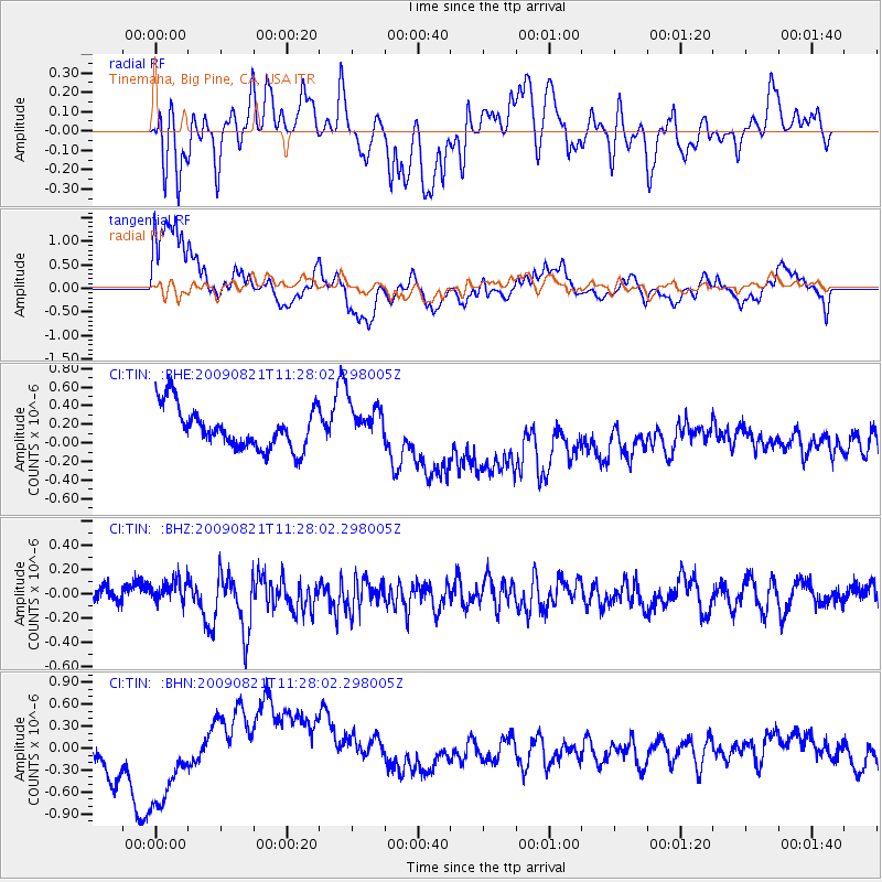
TIN Tinemaha, Big Pine, CA, USA - Earthquake Result Viewer
*The percent match for this event was below the threshold and hence no stack was calculated.
| Earthquake location: |
Southeast Of Loyalty Islands |
| Earthquake latitude/longitude: |
-22.5/171.2 |
| Earthquake time(UTC): |
2009/08/21 (233) 11:15:39 GMT |
| Earthquake Depth: |
10 km |
| Earthquake Magnitude: |
5.7 MW, 5.2 MS, 5.2 MB, 5.6 MW |
| Earthquake Catalog/Contributor: |
WHDF/NEIC |
|
| Network: |
CI Caltech Regional Seismic Network |
| Station: |
TIN Tinemaha, Big Pine, CA, USA |
| Lat/Lon: |
37.05 N/118.23 W |
| Elevation: |
1197 m |
|
| Distance: |
89.0 deg |
| Az: |
48.971 deg |
| Baz: |
240.669 deg |
| Ray Param: |
$rayparam |
*The percent match for this event was below the threshold and hence was not used in the summary stack. |
|
| Radial Match: |
50.94191 % |
| Radial Bump: |
400 |
| Transverse Match: |
50.665375 % |
| Transverse Bump: |
400 |
| SOD ConfigId: |
2622 |
| Insert Time: |
2010-02-25 20:52:40.675 +0000 |
| GWidth: |
2.5 |
| Max Bumps: |
400 |
| Tol: |
0.001 |
|
Signal To Noise
| Channel | StoN | STA | LTA |
| CI:TIN: :BHZ:20090821T11:28:02.298005Z | 1.0135795 | 8.4943444E-8 | 8.38054E-8 |
| CI:TIN: :BHN:20090821T11:28:02.298005Z | 1.2279726 | 3.7216472E-7 | 3.0307248E-7 |
| CI:TIN: :BHE:20090821T11:28:02.298005Z | 0.9840504 | 2.1697193E-7 | 2.2048863E-7 |
| Arrivals |
| Ps | |
| PpPs | |
| PsPs/PpSs | |


