You are here: Home > Network List > US - United States National Seismic Network Stations List
> Station NEW Newport, Washington, USA > Earthquake Result Viewer
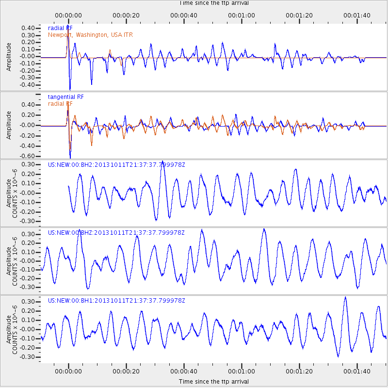
NEW Newport, Washington, USA - Earthquake Result Viewer
*The percent match for this event was below the threshold and hence no stack was calculated.
| Earthquake location: |
Kermadec Islands, New Zealand |
| Earthquake latitude/longitude: |
-30.7/-178.5 |
| Earthquake time(UTC): |
2013/10/11 (284) 21:25:00 GMT |
| Earthquake Depth: |
151 km |
| Earthquake Magnitude: |
6.2 MWW, 6.2 MWW, 6.2 MWB, 6.2 MWC |
| Earthquake Catalog/Contributor: |
NEIC PDE/NEIC COMCAT |
|
| Network: |
US United States National Seismic Network |
| Station: |
NEW Newport, Washington, USA |
| Lat/Lon: |
48.26 N/117.12 W |
| Elevation: |
760 m |
|
| Distance: |
95.8 deg |
| Az: |
36.122 deg |
| Baz: |
229.483 deg |
| Ray Param: |
$rayparam |
*The percent match for this event was below the threshold and hence was not used in the summary stack. |
|
| Radial Match: |
59.38081 % |
| Radial Bump: |
400 |
| Transverse Match: |
51.436523 % |
| Transverse Bump: |
400 |
| SOD ConfigId: |
626651 |
| Insert Time: |
2014-04-19 01:10:03.020 +0000 |
| GWidth: |
2.5 |
| Max Bumps: |
400 |
| Tol: |
0.001 |
|
Signal To Noise
| Channel | StoN | STA | LTA |
| US:NEW:00:BHZ:20131011T21:37:37.799978Z | 2.0491385 | 1.727844E-7 | 8.4320504E-8 |
| US:NEW:00:BH1:20131011T21:37:37.799978Z | 1.2960321 | 1.2582096E-7 | 9.7081674E-8 |
| US:NEW:00:BH2:20131011T21:37:37.799978Z | 2.0722988 | 2.0772117E-7 | 1.0023708E-7 |
| Arrivals |
| Ps | |
| PpPs | |
| PsPs/PpSs | |


