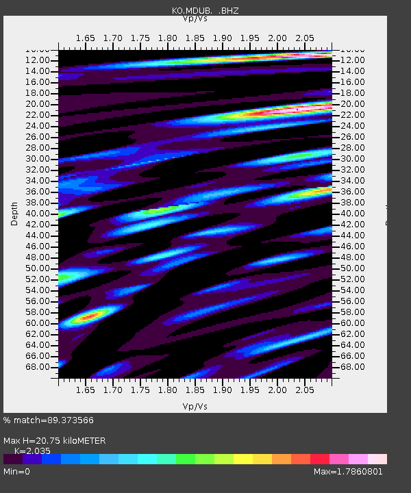
MDUB Mudurnu-Bolu-Turkey - Earthquake Result Viewer

Earthquake location: Near Coast Of Venezuela
Earthquake latitude/longitude: 10.9/-62.3
Earthquake time(UTC): 2013/10/12 (285) 02:10:27 GMT
Earthquake Depth: 63 km
Earthquake Magnitude: 6.0 MWW, 6.0 MWW, 6.0 MWB, 6.0 MWC, 6.0 MI
Earthquake Catalog/Contributor: NEIC PDE/NEIC COMCAT
Network: KO Kandilli Observatory Digital Broadband Seismic Network
Station: MDUB Mudurnu-Bolu-Turkey
Lat/Lon: 40.47 N/31.20 E
Elevation: 1109 m
Distance: 85.7 deg
Az: 49.785 deg
Baz: 280.534 deg
Ray Param: 0.044485576
Estimated Moho Depth: 20.75 km
Estimated Crust Vp/Vs: 2.04
Assumed Crust Vp: 6.287 km/s
Estimated Crust Vs: 3.09 km/s
Estimated Crust Poisson's Ratio: 0.34
Radial Match: 89.373566 %
Radial Bump: 400
Transverse Match: 84.195984 %
Transverse Bump: 400
SOD ConfigId: 626651
Insert Time: 2014-04-19 01:31:01.251 +0000
GWidth: 2.5
Max Bumps: 400
Tol: 0.001

Signal To Noise

ChannelStoNSTALTA
KO:MDUB: :BHZ:20131012T02:22:28.000022Z18.3239652.5645038E-61.3995354E-7
KO:MDUB: :BHN:20131012T02:22:28.000022Z2.60622075.288903E-72.0293383E-7
KO:MDUB: :BHE:20131012T02:22:28.000022Z4.84548239.741117E-72.0103502E-7
Arrivals
Ps3.5 SECOND
PpPs9.8 SECOND
PsPs/PpSs13 SECOND